File:Blinov NASA.jpg
Jump to navigation
Jump to search

Size of this preview: 383 × 599 pixels. Other resolutions: 153 × 240 pixels | 390 × 610 pixels.
Original file (390 × 610 pixels, file size: 75 KB, MIME type: image/jpeg)
Captions
Captions
Add a one-line explanation of what this file represents
Summary[edit]
| Description |
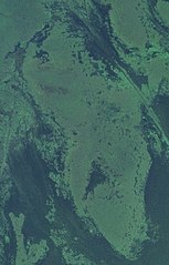
Русский: Полузатопленный и заросший остров в дельте Волги, Каспийское море (Россия). "Суша" показана более светлым оттенком.
English: island (lighter shade) in the Volga delta, Caspian Sea, Russia |
| Date | Unknown date |
| Source | Screenshot from NASA World Wind software, Blue Marble & Landsat layer |
| Author | NASA |
| Object location | | View this and other nearby images on: OpenStreetMap |
|---|
Licensing[edit]
| This image is in the public domain because it is a screenshot from NASA’s globe software World Wind using a public domain layer, such as Blue Marble, MODIS, Landsat, SRTM, USGS or GLOBE.
|
 |
File history
Click on a date/time to view the file as it appeared at that time.
| Date/Time | Thumbnail | Dimensions | User | Comment | |
|---|---|---|---|---|---|
| current | 18:40, 25 April 2023 | | 390 × 610 (75 KB) | Proeksad (talk | contribs) | Uploaded a work by NASA from Screenshot from NASA World Wind software, Blue Marble & Landsat layer with UploadWizard |
You cannot overwrite this file.
File usage on Commons
There are no pages that use this file.
File usage on other wikis
The following other wikis use this file:
- Usage on ceb.wikipedia.org
- Usage on ce.wikipedia.org
- Usage on ru.wikipedia.org
- Usage on www.wikidata.org