File:Blue Ridge Province.jpg
Jump to navigation
Jump to search

Size of this preview: 463 × 599 pixels. Other resolutions: 185 × 240 pixels | 618 × 800 pixels.
Original file (618 × 800 pixels, file size: 90 KB, MIME type: image/jpeg)
Captions
Captions
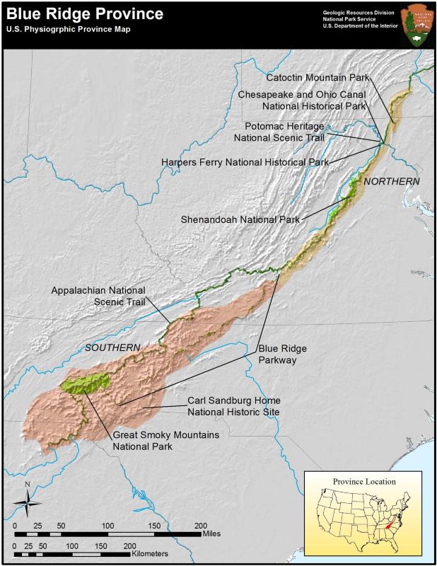
The Blue Ridge Physiographic Province as defined by the U. S. National Park Service.
Summary[edit]
| Description |
English: This is a map of the Blue Ridge Physiographic Province that formed during the Grenville Orogeny about 1.2 billion years ago. The Blue Ridge Mountains are the oldest portion of the Appalachian Mountains. |
| Date | |
| Source | https://www.nps.gov/common/uploads/photogallery/nri/park/geology/49064F30-1DD8-B71B-0B0B2B7503B7B1E0/49064F30-1DD8-B71B-0B0B2B7503B7B1E0-large.jpg |
| Author | National Park Service |
Licensing[edit]
This work is in the public domain in the United States because it is a work prepared by an officer or employee of the United States Government as part of that person’s official duties under the terms of Title 17, Chapter 1, Section 105 of the US Code.
Note: This only applies to original works of the Federal Government and not to the work of any individual U.S. state, territory, commonwealth, county, municipality, or any other subdivision. This template also does not apply to postage stamp designs published by the United States Postal Service since 1978. (See § 313.6(C)(1) of Compendium of U.S. Copyright Office Practices). It also does not apply to certain US coins; see The US Mint Terms of Use.
|
 | |
| This file has been identified as being free of known restrictions under copyright law, including all related and neighboring rights. | ||
File history
Click on a date/time to view the file as it appeared at that time.
| Date/Time | Thumbnail | Dimensions | User | Comment | |
|---|---|---|---|---|---|
| current | 15:38, 13 August 2023 | | 618 × 800 (90 KB) | Deanrah (talk | contribs) | Uploaded a work by National Park Service from https://www.nps.gov/common/uploads/photogallery/nri/park/geology/49064F30-1DD8-B71B-0B0B2B7503B7B1E0/49064F30-1DD8-B71B-0B0B2B7503B7B1E0-large.jpg with UploadWizard |
You cannot overwrite this file.
File usage on Commons
There are no pages that use this file.
File usage on other wikis
The following other wikis use this file:
- Usage on de.wikipedia.org
- Usage on en.wikipedia.org
- Usage on mt.wikipedia.org