File:Bobrowniki (gmina w województwie kujawsko-pomorskim) location map.png
Jump to navigation
Jump to search

Size of this preview: 523 × 599 pixels. Other resolutions: 209 × 240 pixels | 419 × 480 pixels | 722 × 827 pixels.
Original file (722 × 827 pixels, file size: 99 KB, MIME type: image/png)
Captions
Captions
Add a one-line explanation of what this file represents
| Description |
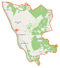
Polski: Mapa gminy Bobrowniki, Polska
English: Map of Gmina Bobrowniki, Poland |
|||||||||
| Date | ||||||||||
| Source | You may find a page on the OpenStreetMap wiki page for Bobrowniki (gmina w województwie kujawsko-pomorskim) | |||||||||
| Creator |
OpenStreetMap contributors OpenStreetMap contributors |
|||||||||
| Permission (Reusing this file) |
OpenStreetMap data is available under the Open Database License (details). Map tiles are licensed under the Creative Commons Attribution-ShareAlike 2.0 license (CC-BY-SA 2.0).
This file is licensed under the Creative Commons Attribution-Share Alike 2.0 Generic license.
|
|||||||||
| Geotemporal data | ||||||||||
| Bounding box |
|
|||||||||
| Georeferencing | If inappropriate please set warp_status = skip to hide. | |||||||||
File history
Click on a date/time to view the file as it appeared at that time.
| Date/Time | Thumbnail | Dimensions | User | Comment | |
|---|---|---|---|---|---|
| current | 07:51, 31 October 2014 | | 722 × 827 (99 KB) | VanWiel (talk | contribs) | {{OpenStreetMap | name = Bobrowniki (gmina w województwie kujawsko-pomorskim) | location = Bobrowniki (gmina w województwie kujawsko-pomorskim) | description = {{pl|Mapa gminy Bobrowniki, Polska}} {{en|Map of Gmina... |
You cannot overwrite this file.
File usage on Commons
The following page uses this file:
File usage on other wikis
The following other wikis use this file:
- Usage on be.wikipedia.org
- Usage on pl.wikipedia.org
- Bobrowniki (gmina w województwie kujawsko-pomorskim)
- Bobrownickie Pole
- Brzustowa
- Polichnowo
- Rachcin
- Stary Bógpomóż
- Stare Rybitwy
- Winduga (województwo kujawsko-pomorskie)
- Bobrowniki (miasto)
- Białe Błota (powiat lipnowski)
- Gnojno (powiat lipnowski)
- Nowy Bógpomóż
- Oparczyska
- Dębowiec (powiat lipnowski)
- Piaski (Polichnowo)
- Okrągła (Rachcin)
- Parcele Łochockie
- Rachcinek
- Stara Rzeczna
- Miszek (Stare Rybitwy)
- Zamek w Bobrownikach
- Parafia św. Anny w Bobrownikach
- Kościół św. Anny w Bobrownikach
- Moduł:Mapa/dane/Bobrowniki (gmina w województwie kujawsko-pomorskim)
- Mogiła na Placu Wolności w Bobrownikach
- Moduł:Mapa/dane/Bobrowniki (miasto)
- Usage on pl.wikibooks.org
- Usage on ru.wikipedia.org
- Usage on www.wikidata.org
_location_map.png&oldid=827350071)