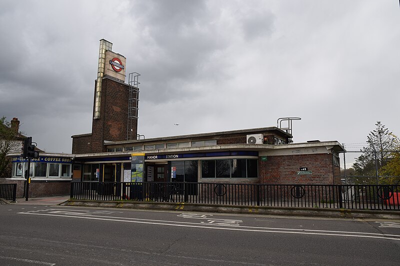
File:Boston Manor Underground Station (Piccadilly Line).jpg

Original file (6,000 × 4,000 pixels, file size: 6.86 MB, MIME type: image/jpeg)
Captions
Captions
Summary[edit]
| DescriptionBoston Manor Underground Station (Piccadilly Line).jpg |
English: Boston Manor Underground Station, 6 April 2023. The original station was opened in May 1883 on the Metropolitan District Railway’s extension from Mill Hill Park (now Acton Town) to Hounslow Town. It was named Boston Road but renamed Boston Manor in 1911. In 1932-34 the station was rebuilt by the Underground Electric Railways of London for the extension of Piccadilly Railway services which began running there in January 1933 when the station opened but before it was completed in March 1934. District Line services ceased serving Boston Manor in October 1964.
Frank Pick, the Managing Director of the UERL, gave the responsibility of designing the new stations on the Acton Town – Hounslow extension to his favoured architectural consultant, Charles Holden, rather than the UERL’s own Chief Architect, Stanley Heaps. Despite this awkward situation, the two architects, to their credit, worked well together and Heaps often acted as site advisor on the construction of Holden’s stations and was sometimes given the responsibility of designing the details, as long as he followed Holden’s Modernist principles. However, in the case of Boston Manor, Holden went further and delegated the design to Heaps, but again, following ‘Holdenesque’ principles – which Heaps accomplished magnificently in this case. Interestingly, although the station building was rebuilt, the platforms were not and thus they remain in their 1883 condition. The station as a whole is a Grade II listed building. Pictured is the station building with the distinctive tower with illuminated strip. |
| Date | |
| Source | https://www.flickr.com/photos/58433307@N08/52825532635/ |
| Author | hugh llewelyn |
| Camera location | 51° 29′ 43.43″ N, 0° 19′ 31.3″ W | View this and other nearby images on: OpenStreetMap |
|---|
Licensing[edit]
- You are free:
- to share – to copy, distribute and transmit the work
- to remix – to adapt the work
- Under the following conditions:
- attribution – You must give appropriate credit, provide a link to the license, and indicate if changes were made. You may do so in any reasonable manner, but not in any way that suggests the licensor endorses you or your use.
- share alike – If you remix, transform, or build upon the material, you must distribute your contributions under the same or compatible license as the original.
| This image was originally posted to Flickr by hugh llewelyn at https://flickr.com/photos/58433307@N08/52825532635. It was reviewed on 22 April 2023 by FlickreviewR 2 and was confirmed to be licensed under the terms of the cc-by-sa-2.0. |
22 April 2023
File history
Click on a date/time to view the file as it appeared at that time.
| Date/Time | Thumbnail | Dimensions | User | Comment | |
|---|---|---|---|---|---|
| current | 14:00, 22 April 2023 |  | 6,000 × 4,000 (6.86 MB) | Oxyman (talk | contribs) | Uploaded a work by hugh llewelyn from https://www.flickr.com/photos/58433307@N08/52825532635/ with UploadWizard |
You cannot overwrite this file.
File usage on Commons
The following page uses this file:
Metadata
This file contains additional information such as Exif metadata which may have been added by the digital camera, scanner, or software program used to create or digitize it. If the file has been modified from its original state, some details such as the timestamp may not fully reflect those of the original file. The timestamp is only as accurate as the clock in the camera, and it may be completely wrong.
| Camera manufacturer | NIKON CORPORATION |
|---|---|
| Camera model | NIKON D5300 |
| Exposure time | 1/250 sec (0.004) |
| F-number | f/8 |
| ISO speed rating | 400 |
| Date and time of data generation | 16:35, 6 April 2023 |
| Lens focal length | 16 mm |
| Orientation | Normal |
| Horizontal resolution | 300 dpi |
| Vertical resolution | 300 dpi |
| Software used | Ver.1.01 |
| File change date and time | 16:35, 6 April 2023 |
| Y and C positioning | Centered |
| Exposure Program | Not defined |
| Exif version | 2.3 |
| Date and time of digitizing | 16:35, 6 April 2023 |
| Meaning of each component |
|
| Image compression mode | 2 |
| APEX exposure bias | 0 |
| Maximum land aperture | 3 APEX (f/2.83) |
| Metering mode | Pattern |
| Light source | Unknown |
| Flash | Flash did not fire, compulsory flash suppression |
| DateTime subseconds | 20 |
| DateTimeOriginal subseconds | 20 |
| DateTimeDigitized subseconds | 20 |
| Supported Flashpix version | 1 |
| Color space | sRGB |
| Sensing method | One-chip color area sensor |
| File source | Digital still camera |
| Scene type | A directly photographed image |
| Custom image processing | Normal process |
| Exposure mode | Auto exposure |
| White balance | Auto white balance |
| Digital zoom ratio | 1 |
| Focal length in 35 mm film | 24 mm |
| Scene capture type | Standard |
| Scene control | Low gain up |
| Contrast | Normal |
| Saturation | Normal |
| Sharpness | Normal |
| Subject distance range | Unknown |
| GPS tag version | 0.0.3.2 |
| Rating (out of 5) | 0 |