File:MBTA Boston subway map.png
(Redirected from File:Boston T undistorted.gif)

Size of this preview: 760 × 599 pixels. Other resolutions: 304 × 240 pixels | 609 × 480 pixels | 974 × 768 pixels | 1,280 × 1,010 pixels | 2,560 × 2,019 pixels | 3,062 × 2,415 pixels.
Original file (3,062 × 2,415 pixels, file size: 650 KB, MIME type: image/png)
Captions
Captions
Add a one-line explanation of what this file represents
Summary
[edit]
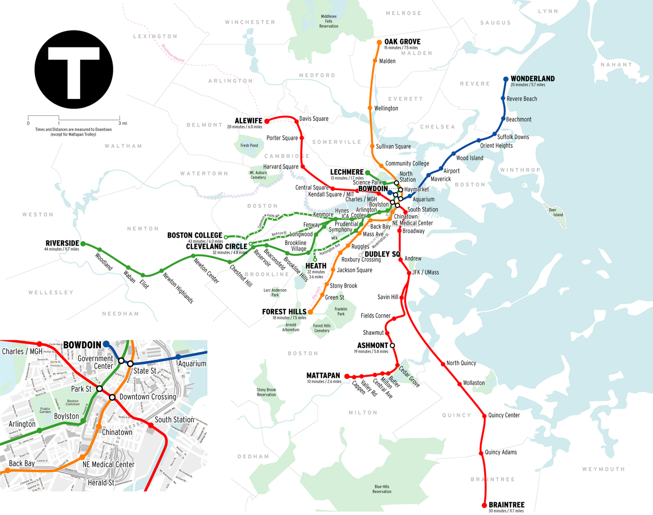
| Description | Geographically accurate map of the Boston "T" |
| Source | self-made (can be seen at http://www.radicalcartography.net/?bostonnow ) |
| Author | Citynoise |
Licensing
[edit]
This file is licensed under the Creative Commons Attribution-Share Alike 3.0 Unported license.
- You are free:
- to share – to copy, distribute and transmit the work
- to remix – to adapt the work
- Under the following conditions:
- attribution – You must give appropriate credit, provide a link to the license, and indicate if changes were made. You may do so in any reasonable manner, but not in any way that suggests the licensor endorses you or your use.
- share alike – If you remix, transform, or build upon the material, you must distribute your contributions under the same or compatible license as the original.
File history
Click on a date/time to view the file as it appeared at that time.
| Date/Time | Thumbnail | Dimensions | User | Comment | |
|---|---|---|---|---|---|
| current | 06:02, 9 July 2011 | | 3,062 × 2,415 (650 KB) | Sswonk (talk | contribs) | sp. Wolaston --> Wollaston |
| 20:30, 17 September 2007 |  | 3,062 × 2,415 (721 KB) | Dread Pirate Westley (talk | contribs) | replaces file by same uploader, originally uploaded at Image:MBTA Boston subway map 2.png. License copied as shown below. == Summary == {{Information |Description= |Source=self-made |Date= |Author= Citynoise }} == Licensing == { | |
| 20:30, 14 September 2007 |  | 1,995 × 1,613 (563 KB) | Dream out loud (talk | contribs) | fixed image cropping | |
| 20:21, 14 September 2007 |  | 1,996 × 1,506 (551 KB) | Dream out loud (talk | contribs) | {{Information |Description=Geographically accurate map of the Boston "T" |Source=http://www.radicalcartography.net/?bostonnow |Date=2003 |Author=Bill Rankin, Louis Hyman |Permission=All maps, t |
You cannot overwrite this file.
File usage on Commons
The following 5 pages use this file:
File usage on other wikis
The following other wikis use this file:
- Usage on be-tarask.wikipedia.org
- Usage on bn.wikibooks.org
- Usage on ca.wikipedia.org
- Usage on de.wikipedia.org
- Usage on en.wikipedia.org
- Usage on en.wikibooks.org
- Usage on en.wikivoyage.org
- Usage on es.wikipedia.org
- Usage on fr.wikipedia.org
- Usage on he.wikivoyage.org
- Usage on id.wikipedia.org
- Usage on it.wikipedia.org
- Usage on ja.wikipedia.org
- Usage on ja.wikivoyage.org
- Usage on ka.wikipedia.org
- Usage on nl.wikipedia.org
- Usage on pt.wikipedia.org
- Usage on ru.wikipedia.org
- Usage on sr.wikipedia.org
- Usage on th.wikipedia.org
- Usage on uk.wikipedia.org
- Usage on uz.wikipedia.org
- Usage on www.wikidata.org
- Usage on zh.wikipedia.org