File:Bratislava boroughs outline map.svg
Jump to navigation
Jump to search

Size of this PNG preview of this SVG file: 525 × 599 pixels. Other resolutions: 210 × 240 pixels | 420 × 480 pixels | 673 × 768 pixels | 897 × 1,024 pixels | 1,794 × 2,048 pixels | 2,072 × 2,365 pixels.
Original file (SVG file, nominally 2,072 × 2,365 pixels, file size: 158 KB)
Captions
Captions
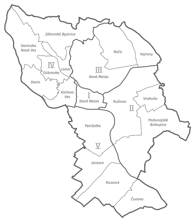
Boroughs of Bratislava
Summary[edit]
| Description |
Slovenčina: Mapa mestských častí Bratislavy
Čeština: Mapa městských částí Bratislavy
English: Map of Bratislava boroughs
Deutsch: Karte der Stadtteile von Bratislava |
||||||
| Date | |||||||
| Source | Own work, using OpenStreetMap data | ||||||
| Author | Krumpi | ||||||
| Other versions |
|
||||||
| SVG development |


Licensing[edit]
I, the copyright holder of this work, hereby publish it under the following license:
This file is licensed under the Creative Commons Attribution-Share Alike 4.0 International license.
- You are free:
- to share – to copy, distribute and transmit the work
- to remix – to adapt the work
- Under the following conditions:
- attribution – You must give appropriate credit, provide a link to the license, and indicate if changes were made. You may do so in any reasonable manner, but not in any way that suggests the licensor endorses you or your use.
- share alike – If you remix, transform, or build upon the material, you must distribute your contributions under the same or compatible license as the original.
File history
Click on a date/time to view the file as it appeared at that time.
| Date/Time | Thumbnail | Dimensions | User | Comment | |
|---|---|---|---|---|---|
| current | 18:15, 11 January 2020 | | 2,072 × 2,365 (158 KB) | Krumpi (talk | contribs) |
You cannot overwrite this file.
File usage on Commons
The following 5 pages use this file: