File:Bucovina-ethnic.png
Jump to navigation
Jump to search
No higher resolution available.
Bucovina-ethnic.png (596 × 289 pixels, file size: 30 KB, MIME type: image/png)
Captions
Captions
Add a one-line explanation of what this file represents
| Description |
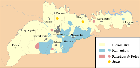
English: Based on the 2001 Ukrainian census. All areas in question are based on the 1910 bukovina map (after the 1910 Austrian census) as well as the latest 2001 ukranian census. |
| Date | 31 October 2006 (original upload date) |
| Source | Transferred from en.wikipedia to Commons by Andrei Stroe using CommonsHelper. |
| Author | Constantzeanu at English Wikipedia |
Licensing[edit]
Constantzeanu at the English-language Wikipedia, the copyright holder of this work, hereby publishes it under the following license:
| This file is licensed under the Creative Commons Attribution-Share Alike 3.0 Unported license. Subject to disclaimers. | ||
| Attribution: Constantzeanu at the English-language Wikipedia | ||
| ||
| This licensing tag was added to this file as part of the GFDL licensing update. |

|
Permission is granted to copy, distribute and/or modify this document under the terms of the GNU Free Documentation License, Version 1.2 or any later version published by the Free Software Foundation; with no Invariant Sections, no Front-Cover Texts, and no Back-Cover Texts. A copy of the license is included in the section entitled GNU Free Documentation License. Subject to disclaimers. |
Original upload log[edit]
The original description page was here. All following user names refer to en.wikipedia.
- 2006-10-31 05:00 Constantzeanu 596×289× (20407 bytes) басед он тхе 2001 украниан сенсус. All areas in question are based on the 1910 bukovina map (after the 1910 austrian census) as well as the latest 2001 ukranian census. == Licensing == {{GFDL-self}} [[Category:Ukrain
- 2006-10-31 04:55 Constantzeanu 596×289× (20407 bytes) басед он тхе 2001 украниан сенсус. All areas in question are based on the 1910 bukovina map (after the 1910 austrian census) as well as the latest 2001 ukranian census. == Licensing == {{GFDL-self}} [[Category:Ukrain
- 2006-10-30 02:30 Constantzeanu 596×289× (20417 bytes) {{PD-self}} newer and more accurate version
- 2006-01-20 03:57 Constantzeanu 596×289× (21258 bytes) басед он тхе 2001 украниан сенсус. All areas in question are based on the 1910 bukovina map (after the 1910 austrian census) as well as the latest 2001 ukranian census.
- 2006-01-11 06:02 Constantzeanu 596×289× (21189 bytes) nicer looking version
- 2006-01-10 04:00 Constantzeanu 596×289× (21238 bytes) басед он тхе 2001 украниан сенсус
File history
Click on a date/time to view the file as it appeared at that time.
| Date/Time | Thumbnail | Dimensions | User | Comment | |
|---|---|---|---|---|---|
| current | 16:30, 29 February 2012 | | 596 × 289 (30 KB) | Constantzeanu (talk | contribs) | added rubric "poles" as Stara Krasnishora (the are in red) is a polish village. |
| 06:31, 24 February 2012 |  | 596 × 289 (31 KB) | Constantzeanu (talk | contribs) | added changes as per latest available detailed village-by-village census results and made changes for voloca village, bahrineshti and stari volchinets. | |
| 03:11, 22 February 2012 |  | 596 × 289 (47 KB) | Constantzeanu (talk | contribs) | (map adjusted to reflect ethnic make-up village-by-village in each of the 11 rayions(raioane) of Chernivtsi/Cernnauti Oblast as well as correct area of boian which was previously incorrectly coded.) | |
| 19:24, 14 February 2012 |  | 596 × 289 (47 KB) | Constantzeanu (talk | contribs) | map adjusted to reflect make-up village-by-village in each of the 11 rayions(raioane) of Chernivtsi/Cernnauti Oblast. | |
| 14:45, 13 April 2009 |  | 596 × 289 (20 KB) | File Upload Bot (Magnus Manske) (talk | contribs) | {{BotMoveToCommons|en.wikipedia|year={{subst:CURRENTYEAR}}|month={{subst:CURRENTMONTHNAME}}|day={{subst:CURRENTDAY}}}} {{Information |Description={{en|басед он тхе 2001 украниан сенсус. All areas in question are based on the 1910 |
You cannot overwrite this file.
File usage on Commons
There are no pages that use this file.
File usage on other wikis
The following other wikis use this file:
- Usage on bg.wikipedia.org
- Usage on de.wikipedia.org
- Usage on en.wikipedia.org
- Usage on es.wikipedia.org
- Usage on fr.wikipedia.org
- Usage on hr.wikipedia.org
- Usage on it.wikipedia.org
- Usage on no.wikipedia.org
- Usage on pl.wikipedia.org
- Usage on ro.wikipedia.org
- Usage on sh.wikipedia.org
- Usage on uk.wikipedia.org
- Usage on zh.wikipedia.org