File:Buildings by the River Calder near Thornes - geograph.org.uk - 1344018.jpg
Jump to navigation
Jump to search
No higher resolution available.
Buildings_by_the_River_Calder_near_Thornes_-_geograph.org.uk_-_1344018.jpg (639 × 282 pixels, file size: 53 KB, MIME type: image/jpeg)
Captions
Captions
Add a one-line explanation of what this file represents
Summary[edit]
| Description |
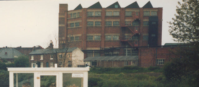
English: Buildings by the River Calder near Thornes. This is part of a photo taken on board a boat (part of which is in the foreground). The reason for submitting it is that the houses in the middle distance, on the river bank, appear from aerial photography to have been demolished since this was taken. The photo was geo-located from the distinctive industrial building in the background, that also appears on 824065 viewed from a different angle. |
| Date | |
| Source | From geograph.org.uk |
| Author | Stephen Craven |
| Attribution (required by the license) | Stephen Craven / Buildings by the River Calder near Thornes / |
| Camera location | | View this and other nearby images on: OpenStreetMap |
|---|
_heading:292.00&language=en)
| Object location | | View this and other nearby images on: OpenStreetMap |
|---|
_heading:292.00&language=en)
Licensing[edit]

|
This image was taken from the Geograph project collection. See this photograph's page on the Geograph website for the photographer's contact details. The copyright on this image is owned by Stephen Craven and is licensed for reuse under the Creative Commons Attribution-ShareAlike 2.0 license.
|
This file is licensed under the Creative Commons Attribution-Share Alike 2.0 Generic license.
Attribution: Stephen Craven
- You are free:
- to share – to copy, distribute and transmit the work
- to remix – to adapt the work
- Under the following conditions:
- attribution – You must give appropriate credit, provide a link to the license, and indicate if changes were made. You may do so in any reasonable manner, but not in any way that suggests the licensor endorses you or your use.
- share alike – If you remix, transform, or build upon the material, you must distribute your contributions under the same or compatible license as the original.
File history
Click on a date/time to view the file as it appeared at that time.
| Date/Time | Thumbnail | Dimensions | User | Comment | |
|---|---|---|---|---|---|
| current | 04:01, 28 February 2011 | | 639 × 282 (53 KB) | GeographBot (talk | contribs) | == {{int:filedesc}} == {{Information |description={{en|1=Buildings by the River Calder near Thornes This is part of a photo taken on board a boat (part of which is in the foreground). The reason for submitting it is that the houses in the middle distance |
You cannot overwrite this file.
File usage on Commons
There are no pages that use this file.