File:Buurtspoorwegen West-Vlaanderen.png
Jump to navigation
Jump to search

Size of this preview: 516 × 600 pixels. Other resolutions: 206 × 240 pixels | 413 × 480 pixels | 661 × 768 pixels | 881 × 1,024 pixels | 1,829 × 2,125 pixels.
Original file (1,829 × 2,125 pixels, file size: 1.48 MB, MIME type: image/png)
Captions
Captions
Add a one-line explanation of what this file represents
Summary[edit]
| Description |
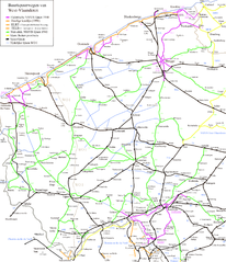
English: Map off the vicinal railways in the province of West Flandres.
Nederlands: Kaart van de buurtspoorwegen in de provincie West-Vlaanderen. |
| Date | (buurtspoorwegen) |
| Source | Own work |
| Author | Smiley.toerist |
Licensing[edit]
I, the copyright holder of this work, hereby publish it under the following licenses:

|
Permission is granted to copy, distribute and/or modify this document under the terms of the GNU Free Documentation License, Version 1.2 or any later version published by the Free Software Foundation; with no Invariant Sections, no Front-Cover Texts, and no Back-Cover Texts. A copy of the license is included in the section entitled GNU Free Documentation License. |
This file is licensed under the Creative Commons Attribution-Share Alike 3.0 Unported, 2.5 Generic, 2.0 Generic and 1.0 Generic license.
- You are free:
- to share – to copy, distribute and transmit the work
- to remix – to adapt the work
- Under the following conditions:
- attribution – You must give appropriate credit, provide a link to the license, and indicate if changes were made. You may do so in any reasonable manner, but not in any way that suggests the licensor endorses you or your use.
- share alike – If you remix, transform, or build upon the material, you must distribute your contributions under the same or compatible license as the original.
You may select the license of your choice.
File history
Click on a date/time to view the file as it appeared at that time.
| Date/Time | Thumbnail | Dimensions | User | Comment | |
|---|---|---|---|---|---|
| current | 00:12, 28 March 2012 | | 1,829 × 2,125 (1.48 MB) | Smiley.toerist (talk | contribs) | Corrections applied |
| 10:53, 22 February 2011 |  | 1,829 × 2,125 (1.48 MB) | Smiley.toerist (talk | contribs) | Franse tramlijnen ELRT en TELB bijgewerkt. | |
| 23:46, 11 January 2011 |  | 1,829 × 2,125 (1.47 MB) | Smiley.toerist (talk | contribs) | ELRT lijnen in Tourcoing/Roubaix | |
| 21:58, 15 December 2010 |  | 1,829 × 2,125 (1.47 MB) | Smiley.toerist (talk | contribs) | Updates: Tram Armentieres + Trams in France | |
| 22:23, 7 June 2010 |  | 1,829 × 2,125 (1.46 MB) | Smiley.toerist (talk | contribs) | ||
| 21:55, 11 August 2009 |  | 1,829 × 2,125 (1.43 MB) | Smiley.toerist (talk | contribs) | ||
| 12:54, 13 March 2009 |  | 1,829 × 2,125 (1.39 MB) | Smiley.toerist (talk | contribs) | ||
| 10:49, 13 March 2009 |  | 1,829 × 2,125 (1.39 MB) | Smiley.toerist (talk | contribs) | ||
| 14:50, 6 February 2009 |  | 1,829 × 2,125 (1.37 MB) | Smiley.toerist (talk | contribs) | ||
| 12:52, 2 February 2009 |  | 1,829 × 2,125 (1.37 MB) | Smiley.toerist (talk | contribs) |
You cannot overwrite this file.
File usage on Commons
The following 2 pages use this file:
File usage on other wikis
The following other wikis use this file:
- Usage on cs.wikipedia.org
- Usage on de.wikipedia.org
- Usage on en.wikipedia.org
- Usage on eo.wikipedia.org
- Usage on fr.wikipedia.org
- Société nationale des chemins de fer vicinaux
- SNCV Groupe de Zwevezele
- Lignes de tramway de la SNCV dans la province de Flandre-Occidentale
- Ligne de tramway 351
- Ligne de tramway KMx
- Ligne de tramway 365
- Ligne de tramway MP
- Ligne de tramway 372 Courtrai Station-État - Pecq Place
- Ligne de tramway 366
- Ligne de tramway 354
- Ligne de tramway 361
- Ligne de tramway 360
- Ligne de tramway 353B
- Ligne de tramway 357
- Ligne de tramway 348A
- Ligne de tramway 7 (SNCV Groupe de la Côte)
- Ligne de tramway 9 (SNCV Groupe de la Côte)
- Ligne de tramway 20 (SNCV Groupe de la Côte)
- Ligne de tramway 21 (SNCV Groupe de la Côte)
- Ligne de tramway 10 (SNCV Groupe de Zwevezele)
- Ligne de tramway 12 (SNCV Groupe de Zwevezele)
- Ligne de tramway 13 (SNCV Groupe de Zwevezele)
- Ligne de tramway 14 (SNCV Groupe de Zwevezele)
- Ligne de tramway 1 (SNCV Groupe de Zwevezele)
- Ligne de tramway 2 (SNCV Groupe de Zwevezele)
- Ligne de tramway 3 (SNCV Groupe de Zwevezele)
- Ligne de tramway 4 (SNCV Groupe de Zwevezele)
- Ligne de tramway 5 (SNCV Groupe de Zwevezele)
- Ligne de tramway 6 (SNCV Groupe de Zwevezele)
- Ligne de tramway 329
- Ligne de tramway 338
- Ligne de tramway 341
- Ligne de tramway 342
- Usage on nl.wikipedia.org