File:Córdova, Argentina.jpg
Jump to navigation
Jump to search

Size of this preview: 600 × 600 pixels. Other resolutions: 240 × 240 pixels | 480 × 480 pixels | 768 × 768 pixels | 1,081 × 1,081 pixels.
Original file (1,081 × 1,081 pixels, file size: 711 KB, MIME type: image/jpeg)
Captions
Captions
Add a one-line explanation of what this file represents
Summary[edit]
| Description |
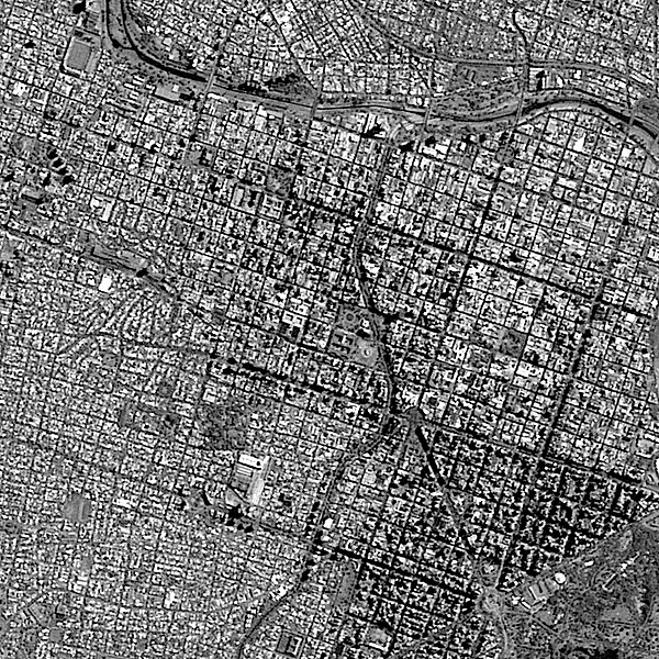
Português: Córdova, Argentina, onde o córrego La Cañada, linha escura cruzando o meio da imagem de S a N, deságua no Rio Suquia, que corre de O a L na parte de cima da imagem. No canto superior esquerdo, o retangulo cinza é o campo de futebol do Estadio Julio César Villagra do lubatleticobelgrano, também conhecido como El Gigante de Alberdi. No canto inferior dir. está o vasto Parque Sarmiento, com áreas para piquenique, trilhas e lago artificial com aluguel de barcos. Ao N e a O do parque, destacada pela cor escura da sombra dos seus edifícios, está o centro de Córdova, conhecido como Nueva Córdoba / Córdoba, Argentina, where La Cañada creek, dark line crossing image middle S to N, flows out into Suquia River, running W to E along image top. Gray rectangle at image upper left corner is Club Atlético Belgrano Julio César Villagra Stadium soccer field, also known as The Alberdi Giant. Large Sarmiento Park is at image lower right corner, with picnic areas, trails and artifical lake with boat rental. N and W of the park, noticeable by its buildings dark shadows, is dowtown Córdoba, known as Nueva Córdoba.
Imagem / Image CBERS4 PAN5m Córdova, Argentina Coordenadas do centro da imagem / Image center: 31°25'01.6"S 64°11'36.5"W Data / Date: 28-02-2019 / 2019-28-02 P&B Cena / Scene: 171 / 135 Autor / Author: Oton Barros (DSR/OBT/INPE) Imagem em HD / HD Image Visite-nos / Visit us: www.dsr.inpe.br |
| Date | |
| Source | https://www.flickr.com/photos/153282474@N02/32746714707/ |
| Author | Coordenação-Geral de Observação da Terra/INPE |
Licensing[edit]
This file is licensed under the Creative Commons Attribution-Share Alike 2.0 Generic license.
- You are free:
- to share – to copy, distribute and transmit the work
- to remix – to adapt the work
- Under the following conditions:
- attribution – You must give appropriate credit, provide a link to the license, and indicate if changes were made. You may do so in any reasonable manner, but not in any way that suggests the licensor endorses you or your use.
- share alike – If you remix, transform, or build upon the material, you must distribute your contributions under the same or compatible license as the original.
| This image was originally posted to Flickr by Coordenação-Geral de Observação da Terra/INPE at https://flickr.com/photos/153282474@N02/32746714707. It was reviewed on 9 April 2020 by FlickreviewR 2 and was confirmed to be licensed under the terms of the cc-by-sa-2.0. |
File history
Click on a date/time to view the file as it appeared at that time.
| Date/Time | Thumbnail | Dimensions | User | Comment | |
|---|---|---|---|---|---|
| current | 10:13, 9 April 2020 | | 1,081 × 1,081 (711 KB) | Jo-Jo Eumerus (talk | contribs) | Uploaded a work by Coordenação-Geral de Observação da Terra/INPE from https://www.flickr.com/photos/153282474@N02/32746714707/ with UploadWizard |
You cannot overwrite this file.
File usage on Commons
The following 2 pages use this file:
- Córdoba (Argentina)
- File:Córdova, Argentina (32746714707).jpg (file redirect)
.jpg&redirect=no)