File:CH-NB - Belgisch-Kongo, Lisala- Landschaft - Annemarie Schwarzenbach - SLA-Schwarzenbach-A-5-25-167.jpg

Original file (4,526 × 4,484 pixels, file size: 11.51 MB, MIME type: image/jpeg)
Captions
Captions
Summary[edit]
| Photographer |
|
||||||||||||||||||||||||||
| Description |
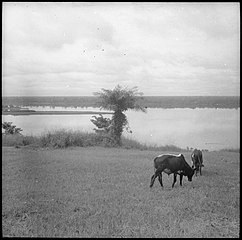
Belgisch-Kongo, Lisala: Landschaft; Zwei Kühe mit dem Fluss Kongo im Hintergrund |
||||||||||||||||||||||||||
| Date | from May 1941 until March 1942 | ||||||||||||||||||||||||||
| Collection |
|
||||||||||||||||||||||||||
| Current location |
Swiss Literary Archives |
||||||||||||||||||||||||||
| Notes |
Der Kongo bei Lisala, ca 1200 km stromaufwärts von Leopoldville. Lisala liegt auf einem Hügel-.Posten mit 30-40 weissen Beamten u. belg. oder portug. Händlern. 5 km von Lisala die B.M.S. (Babtist Missionary Society) von Upoto. (Schlechte Aufnahmen) [handschriftlicher Eintrag auf Karteikarte]39 |
||||||||||||||||||||||||||
| Source | https://www.helveticarchives.ch/detail.aspx?ID=293222 | ||||||||||||||||||||||||||
| Permission (Reusing this file) |
|
||||||||||||||||||||||||||


| Object location | | View this and other nearby images on: OpenStreetMap |
|---|
File history
Click on a date/time to view the file as it appeared at that time.
| Date/Time | Thumbnail | Dimensions | User | Comment | |
|---|---|---|---|---|---|
| current | 14:43, 23 August 2017 | | 4,526 × 4,484 (11.51 MB) | Swiss National Library (talk | contribs) | GWToolset: Creating mediafile for Swiss National Library. |
You cannot overwrite this file.
File usage on Commons
The following page uses this file:
File usage on other wikis
The following other wikis use this file:
- Usage on fr.wikipedia.org