File:Caltrans map.png
Caltrans_map.png (347 × 400 pixels, file size: 20 KB, MIME type: image/png)
Captions
Captions
| Description |
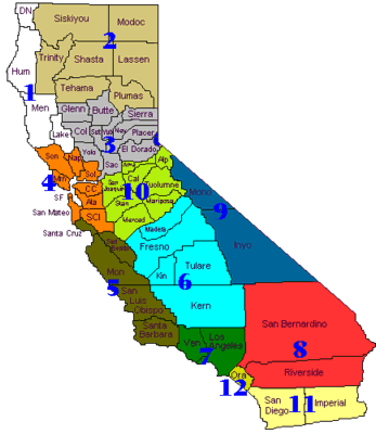
English: Map of California Department of Transportation districts |
|||
| Source | http://www.dot.ca.gov/localoffice.htm | |||
| Author | California Department of Transportation | |||
| Permission (Reusing this file) |
|

Original upload log[edit]
| Date/Time | Dimensions | User | Comment |
|---|---|---|---|
| 29 October 2011, 13:26:07 | 347 × 400 (19180 bytes) | Presidentman (talk · contribs) | {{Information |Description ={{en|1=Map of [[w:California Department of Transportation|California Department of Transportation]] districts}} |Source =http://www.dot.ca.gov/localoffice.htm |Author =[[w:California Department of Transportat |
File history
Click on a date/time to view the file as it appeared at that time.
| Date/Time | Thumbnail | Dimensions | User | Comment | |
|---|---|---|---|---|---|
| current | 05:52, 29 August 2014 | | 347 × 400 (20 KB) | GifTagger (talk | contribs) | Bot: Converting file to superior PNG file. (Source: Caltrans_map.gif). This GIF was problematic due to non-greyscale color table. |
You cannot overwrite this file.
File usage on Commons
The following page uses this file:
- File:Caltrans map.gif (file redirect)
File usage on other wikis
The following other wikis use this file:
- Usage on nl.wikipedia.org