File:CapeFLYER 2013 map.svg
Jump to navigation
Jump to search

Size of this PNG preview of this SVG file: 600 × 600 pixels. Other resolutions: 240 × 240 pixels | 480 × 480 pixels | 768 × 768 pixels | 1,024 × 1,024 pixels | 2,048 × 2,048 pixels | 1,080 × 1,080 pixels.
Original file (SVG file, nominally 1,080 × 1,080 pixels, file size: 420 KB)
Captions
Captions
Add a one-line explanation of what this file represents
Summary
[edit]| Description |
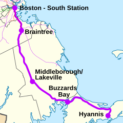
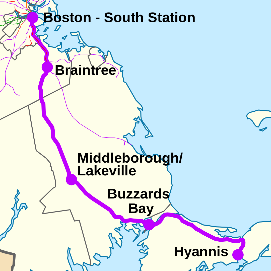
English: Map showing the 2013 route of the MBTA/CCRTA/MassDOT CapeFLYER weekend rail service. Other MBTA commuter rail and rapid transit lines are also shown. |
||
| Date | (UTC) | ||
| Source |
This file was derived from: USA Massachusetts location map.svg:
|
||
| Author |
|
||
| Other versions |
|


Licensing
[edit]
I, the copyright holder of this work, hereby publish it under the following licenses:
This file is licensed under the Creative Commons Attribution 3.0 Unported license.
- You are free:
- to share – to copy, distribute and transmit the work
- to remix – to adapt the work
- Under the following conditions:
- attribution – You must give appropriate credit, provide a link to the license, and indicate if changes were made. You may do so in any reasonable manner, but not in any way that suggests the licensor endorses you or your use.

|
Permission is granted to copy, distribute and/or modify this document under the terms of the GNU Free Documentation License, Version 1.2 or any later version published by the Free Software Foundation; with no Invariant Sections, no Front-Cover Texts, and no Back-Cover Texts. A copy of the license is included in the section entitled GNU Free Documentation License. |
You may select the license of your choice.
Original upload log
[edit]
This image is a derivative work of the following images:
- File:USA_Massachusetts_location_map.svg licensed with Cc-by-3.0, GFDL
- 2009-07-05T11:13:36Z Alexrk2 1050x717 (249369 Bytes) resize
- 2009-06-25T19:38:19Z Alexrk2 800x546 (242956 Bytes) == Beschreibung == {{Information |Description= {{de|Positionskarte von [[:de:Massachusetts|Massachusetts]], [[:de:USA|USA]]}} Quadratische Plattkarte, N-S-Streckung 130.0 %. Geographische Begrenzung der Karte: * N: 43.1° N *
Uploaded with derivativeFX
File history
Click on a date/time to view the file as it appeared at that time.
| Date/Time | Thumbnail | Dimensions | User | Comment | |
|---|---|---|---|---|---|
| current | 18:57, 5 April 2013 | | 1,080 × 1,080 (420 KB) | Pi.1415926535 (talk | contribs) | Hiding intermediate stations except Braintree - not considered part of service |
| 03:00, 20 February 2013 |  | 1,080 × 1,080 (438 KB) | Pi.1415926535 (talk | contribs) | Added intermediate stations | |
| 04:41, 6 February 2013 |  | 1,080 × 1,080 (438 KB) | Pi.1415926535 (talk | contribs) | == {{int:filedesc}} == {{Information |Description={{en|Map showing the 2013 route of the MBTA/CCRTA/MassDOT CapeFLYER weekend rail service. Other MBTA commuter rail and rapid transit lines are also shown.}} |Source={{Derived from|USA_Massachusetts_loca... |
You cannot overwrite this file.
File usage on Commons
The following 3 pages use this file: