File:Caroline Islands-map.gif
Jump to navigation
Jump to search
No higher resolution available.
Caroline_Islands-map.gif (326 × 350 pixels, file size: 9 KB, MIME type: image/gif)
Captions
Captions
Add a one-line explanation of what this file represents

|
This map image could be re-created using vector graphics as an SVG file. This has several advantages; see Commons:Media for cleanup for more information. If an SVG form of this image is available, please upload it and afterwards replace this template with
{{vector version available|new image name}}.
It is recommended to name the SVG file “Caroline Islands-map.svg”—then the template Vector version available (or Vva) does not need the new image name parameter. |
Summary
[edit]
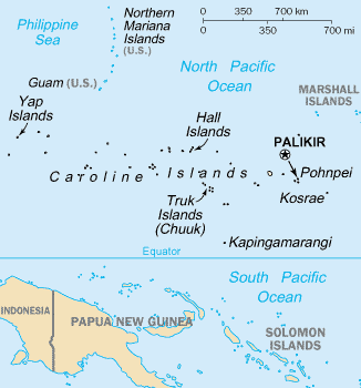
- English: Map of the Caroline Islands Archipelago — located in the Micronesia region of Oceania, in the western Pacific Ocean.
- The central and western islands are in the Federated States of Micronesia, and the eastern are in the Republic of Palau.
- The archipelago is north of the island of New Guinea and the Salomon Islands Archipelago.
Credits
[edit]
- From https://www.cia.gov/library/publications/the-world-factbook/geos/fm.html archive copy at the Wayback Machine
This image is in the public domain because it contains materials that originally came from the United States Central Intelligence Agency's World Factbook.
|
 |
File history
Click on a date/time to view the file as it appeared at that time.
| Date/Time | Thumbnail | Dimensions | User | Comment | |
|---|---|---|---|---|---|
| current | 17:07, 19 June 2010 | | 326 × 350 (9 KB) | Ras67 (talk | contribs) | cropped |
| 17:27, 10 August 2005 |  | 330 × 354 (10 KB) | Bradipus (talk | contribs) | Caroline Islands From http://www.cia.gov/cia/publications/factbook/geos/fm.html {{PD-USGov-CIA-WF}} |
You cannot overwrite this file.
File usage on Commons
The following 2 pages use this file:
File usage on other wikis
The following other wikis use this file:
- Usage on af.wikipedia.org
- Usage on azb.wikipedia.org
- Usage on az.wikipedia.org
- Usage on cs.wikipedia.org
- Usage on en.wikipedia.org
- Caroline Islands
- Operation Hailstone
- User talk:BorgQueen
- User talk:Rsrikanth05
- User talk:Awkwafaba
- User talk:Casliber
- User talk:Sjones23
- User talk:Mark Miller
- User talk:AuthorAuthor
- User talk:Another Believer
- User talk:GDibyendu
- User talk:Becky Sayles
- Carolinian people
- User talk:Moswento
- User talk:John Cline
- User talk:BabbaQ
- User talk:JohnChrysostom
- User talk:Mahensingha
- User talk:WaitingForConnection/Archive 8
- User talk:Tomásdearg92
- User talk:Hypoplectrus
- User talk:RexRowan
- User talk:Jesus Presley/Archive
- Wikipedia:Articles for improvement/Schedule
- User talk:Masssly
- User:Misbah282/sandbox
- User talk:Bananasoldier
- User talk:Wer900/Archive1
- Wikipedia:Articles for improvement/Automation
- User talk:GDibyendu/archive4
- User talk:NickPenguin/Archive 3
- Wikipedia:Articles for improvement/Holding area/old
- User talk:Andrewman327/Archive 1
- User talk:Espresso Addict/archive9
- User talk:Revolution1221
- Template:Article for improvement banner/Picture box
- User talk:Toshio Yamaguchi/Archive 5
- User talk:CaroleHenson/Archive 5
- User talk:Ryan Vesey/Archive 23
- User talk:Evad37/Archive 2
- User talk:Sam Sailor
- User talk:AutomaticStrikeout/Archive 11
- User talk:Dennis Brown/Archive 26
- User talk:MissBono/Archive 5
View more global usage of this file.