File:CarteDuTunnelMontRoyal.jpg
Jump to navigation
Jump to search

Size of this preview: 800 × 370 pixels. Other resolutions: 320 × 148 pixels | 640 × 296 pixels | 1,188 × 550 pixels.
Original file (1,188 × 550 pixels, file size: 127 KB, MIME type: image/jpeg)
Captions
Captions
Add a one-line explanation of what this file represents
Summary[edit]
| Description |
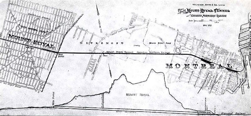
English: Plan of the “Model City”, Mount Royal for the Canadian Northern Railway showing the proposed street plan as well as the tunnel layout through Outremont to downtown Montréal and cross section of the Mount Royal.
Actual street plan is different.
Français : Plan de la « cité modèle » de Mont-Royal montrant le plan des rues proposé, le tunnel passant à travers Outremont, le mont Royal et aboutissant au centre-ville de Montréal. Le plan des rues est aujourd'hui différent. La carte a été dessinée par MacKenzie, Mann & Co. Ltd pour la Canadian Northern Railway au mois de mai 1913. |
| Date | |
| Source | Scanned map |
| Author | MacKenzie, Mann & Co. Ltd |
Licensing[edit]
This media file is in the public domain in the United States. This applies to U.S. works where the copyright has expired, often because its first publication occurred prior to January 1, 1929, and if not then due to lack of notice or renewal. See this page for further explanation.
|
 | |
 |
This image might not be in the public domain outside of the United States; this especially applies in the countries and areas that do not apply the rule of the shorter term for US works, such as Canada, Mainland China (not Hong Kong or Macao), Germany, Mexico, and Switzerland. The creator and year of publication are essential information and must be provided. See Wikipedia:Public domain and Wikipedia:Copyrights for more details.
|
Original upload log[edit]
The original description page was here. All following user names refer to en.wikipedia.
- 2006-07-25 23:50 Emdx 1188×550× (129926 bytes) =Plan of the Mount-Royal Tunnel= By MacKenzie, Mann & Co. Ltd for the [[Canadian Northern Railway]] May 1913. Plan of the “Model City”, [[Mount Royal, Quebec]] showing the proposed street plan as well as the tunnel layout through [[Outremont]] to dow
File history
Click on a date/time to view the file as it appeared at that time.
| Date/Time | Thumbnail | Dimensions | User | Comment | |
|---|---|---|---|---|---|
| current | 19:11, 15 August 2012 | | 1,188 × 550 (127 KB) | Jeangagnon (talk | contribs) | {{Information |Description={{en|By MacKenzie, Mann & Co. Ltd for the en:Canadian Northern Railway May 1913. Plan of the “Model City”, en:Mount Royal, Quebec showing the proposed street plan as well as the tunnel layout through [[:en:Ou... |
You cannot overwrite this file.
File usage on Commons
There are no pages that use this file.
File usage on other wikis
The following other wikis use this file:
- Usage on bg.wikipedia.org
- Usage on de.wikipedia.org
- Usage on en.wikipedia.org
- Usage on fr.wikipedia.org
- Usage on it.wikipedia.org