File:Cerro Bayo volcanic complex.jpg
Jump to navigation
Jump to search
No higher resolution available.
Cerro_Bayo_volcanic_complex.jpg (640 × 422 pixels, file size: 76 KB, MIME type: image/jpeg)
Captions
Captions
Add a one-line explanation of what this file represents
Summary[edit]
| Description |
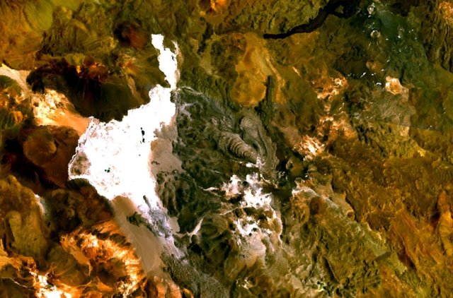
English: The Cerro Bayo volcanic complex lies along the Chile-Argentina border east of the Salar de Gorbea, the light-colored area at the left-center portion of this NASA Landsat image. A young well-preserved crater can be seen NE of an older snow-covered center (bottom-center). A younger northern center along the national border has a well-preserved 400-m-wide crater. The 5401-m-high summit of the Cerro Bayo complex, located west of the border in Chile, is the source of two viscous dacitic lava flows with prominent levees that traveled to the north. |
| Date | Unknown date |
| Source | http://www.volcano.si.edu/world/volcano.cfm?vnum=1505-122&volpage=photos&photo=115041 |
| Author | NASA Landsat7 image (worldwind.arc.nasa.gov) |
Licensing[edit]
| This image is in the public domain because it is a screenshot from NASA’s globe software World Wind using a public domain layer, such as Blue Marble, MODIS, Landsat, SRTM, USGS or GLOBE.
|
 |
File history
Click on a date/time to view the file as it appeared at that time.
| Date/Time | Thumbnail | Dimensions | User | Comment | |
|---|---|---|---|---|---|
| current | 09:43, 23 August 2010 | | 640 × 422 (76 KB) | Michael Metzger (talk | contribs) | {{Information |Description={{en|1=The Cerro Bayo volcanic complex lies along the Chile-Argentina border east of the Salar de Gorbea, the light-colored area at the left-center portion of this NASA Landsat image. A young well-preserved crater can be seen NE |
You cannot overwrite this file.
File usage on Commons
There are no pages that use this file.
File usage on other wikis
The following other wikis use this file:
- Usage on arz.wikipedia.org
- Usage on de.wikipedia.org
- Usage on en.wikipedia.org
- Usage on eo.wikipedia.org
- Usage on es.wikipedia.org
- Usage on eu.wikipedia.org
- Usage on fa.wikipedia.org
- Usage on fr.wikipedia.org
- Usage on it.wikipedia.org
- Usage on pt.wikipedia.org
- Usage on ru.wikipedia.org
- Usage on sv.wikipedia.org
- Usage on uk.wikipedia.org
- Usage on www.wikidata.org
Metadata
Categories:
- Complex volcanoes
- Dacite volcanoes in South America
- Lava fields in Argentina
- Lava fields in Chile
- Lava flows in Argentina
- Levees (volcanism)
- Mountains of Argentina
- Mountains of Chile
- Salt flats of Argentina
- Salar de Gorbea
- Satellite pictures of volcanoes in Argentina
- Satellite pictures of volcanoes in Chile
- Volcanoes in Argentina
- Volcanoes in Chile
- Lava flows in Chile
- Andesite volcanoes in South America
- Basaltic andesite volcanoes in South America
- Volcanic complexes in South America
- NASA World Wind
- Mountains and mountain ranges at international borders in South America
- Cerro Baya Gorbea volcanic complex