File:Chain of Pits on Pavonis Mons.gif
Jump to navigation
Jump to search

Size of this preview: 504 × 599 pixels. Other resolutions: 202 × 240 pixels | 404 × 480 pixels | 659 × 783 pixels.
Original file (659 × 783 pixels, file size: 343 KB, MIME type: image/gif)
Captions
Captions
Add a one-line explanation of what this file represents
Summary[edit]
| Description |
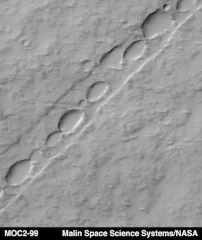
Original captionPavonis Mons is the middle of the three large Tharsis Montes volcanoes in the martian western hemisphere. Located on the equator at about 113°W longitude, Pavonis Mons stands as much as 7 kilometers (4 miles) above the surrounding plain. The Mars Global Surveyor (MGS) Mars Orbiter Camera (MOC) recently spied the above chain of elliptical pits on the lower east flank of Pavonis Mons. The picture covers an area 3 kilometers (1.9 miles) wide by 3.4 kilometers (2.1 miles) in length. The pits are aligned down the center of a 485 meters-(530 yards)-wide, shallow trough. The straight trough and the pits were both formed by collapse associated with faulting. The scarp on each side of the trough is a fault line--troughs of this type are known to geologists as graben. Such features are typically formed when the ground is being moved apart by tectonic forces, or when the ground is uplifted by molten rock injected into the near sub-surface from deeper underground. Both processes may be contributing to the features seen on Pavonis Mons. The pits follow the trend of these faults, and indicate the locus of collapse. Illumination is from the upper left in this image. |
| Source | http://mars.jpl.nasa.gov/mgs/msss/camera/images/3_23_99_pavonis/index.html |
| Author | Malin Space Science Systems/NASA |
Licensing[edit]
| This file is in the public domain in the United States because it was solely created by NASA. NASA copyright policy states that "NASA material is not protected by copyright unless noted". (See Template:PD-USGov, NASA copyright policy page or JPL Image Use Policy.) | ||
 |
Warnings:
|
File history
Click on a date/time to view the file as it appeared at that time.
| Date/Time | Thumbnail | Dimensions | User | Comment | |
|---|---|---|---|---|---|
| current | 19:09, 28 April 2008 | | 659 × 783 (343 KB) | Njardarlogar (talk | contribs) | {{Information |Description= == Original caption == Pavonis Mons is the middle of the three large Tharsis Montes volcanoes in the martian western hemisphere. Located on the equator at about 113°W longitude, Pavonis Mons stands as much as 7 kilometers (4 |
You cannot overwrite this file.
File usage on Commons
The following page uses this file:
- File:Chain of Pits on Pavonis Mons .gif (file redirect)
File usage on other wikis
The following other wikis use this file:
- Usage on nn.wikipedia.org