File:Chatillon-loing-douves-bd republique-4.JPG
Original file (3,648 × 2,736 pixels, file size: 2.48 MB, MIME type: image/jpeg)
Captions
Captions
Summary[edit]
| Description |
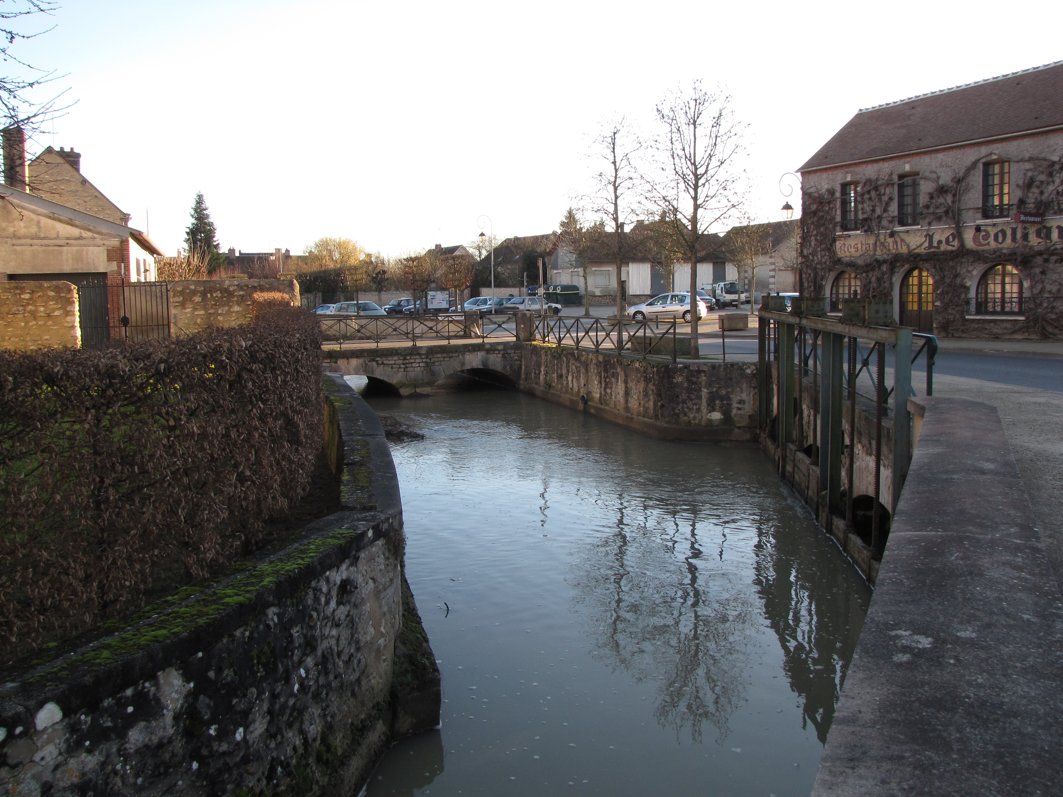
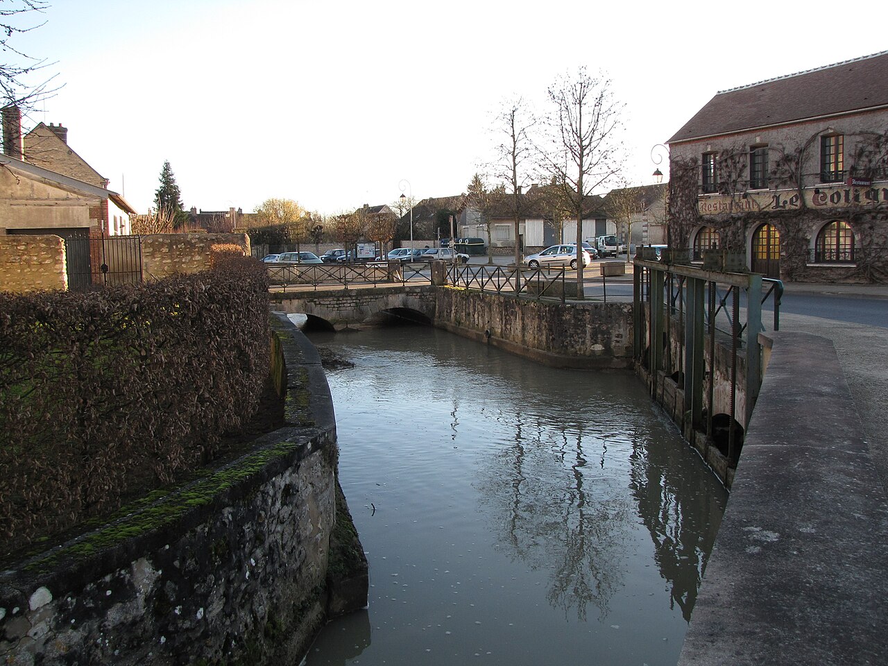
English: Châtillon-Coligny, Loiret, Centre region, France.
Boulevard de la République, beside the "Le Coligny" restaurant (first building on the right). We see the moat surrounding the old town (which stands on the left). This is also the place where what is likely the original Loing riverbed, leaves the moat to head west; on the right side of the moat we can see the sluice regulating its flow.Français : Châtillon-Coligny, Loiret, région Centre.
Boulevard de la République, à côté du restaurant "Le Coligny" (premier bâtiment sur la droite). Nous voyons les douves entourant la vieille ville, à l'endroit où les quitte ce qui est probablement l'ancien lit du Loing ou proche de celui-ci. Sur le côté droit des douves se trouve la vanne régulant son écoulement. |
| Date | |
| Source | Own work |
| Author | Basicdesign |
| Camera location | | View this and other nearby images on: OpenStreetMap |
|---|
Between these two points 2.55 miles apart, most of the Loing's water feeds only the canal. But an arm of the canal (and thus some of the Loing's waters) goes to feed the old moat. This canal arm is about 550 yards long, and is prolongated by a small waterway that splits itself in two parallel arms 120 yards after it left the end of the canal. These two parallel waterways meet with the old moat 160 yards further away. After having followed the moat for about 250 yards, a waterway leaves it, possibly to follow the Loing's original bed ; 650 yards further, it receives the Milleron; and then reaches the déversoir de la Ronce and recuperates the water that it had given to the canal when upstream from town. The Milleron originally flowed under the castle, eastside of town which did not exist then: a pond stood in its place, recorded in 1293. Then in 1376, royal authorisation was given to build the town's fortifications - which included a rather large moat all around. Probably shortly after that, the Milleron was rechannelled so that it too would feed the new moat (it likely helped drying up the land too, so that more houses could be built nearest to the castle).
When the Milleron comes out of the moat on the other side of the town, it gets back into its original bed and reaches the Loing's original bed before the latter gets the rest of its water back from the canal at the déversoir de la Ronce.Entre ces deux points distants de 2,5 km (en suivant le fil de l'eau), la plus grande partie du cours du Loing transite par le canal de Briare. Mais un bras du canal (et donc une partie du Loing) va alimenter les anciennes douves des fortifications. Ce bras de canal est long de 500 m, et se prolonge par un petit cours d'eau qui se partage 110 m après la fin du canal en deux voies d'eau parallèles. Ces deux voies parallèles rejoignent les anciennes douves 150 m plus loin. Ayant suivi le cours des douves pendant environ 230 m, une voie d'eau s'en sépare, probablement pour suivre le cours originel du Loing. A 600 m en aval de cette séparation d'avec les douves, il reçoit son affluent le Milleron. Puis il rejoint le déversoir de la Ronce et récupère l'eau qu'il avait donné au canal en amont de la ville.
Le Milleron coulait originellement sous le château, à l’est de la ville dont l'emplacement était occupé par un étang signalé dès 1293. Postérieurement à cette date, le Milleron a été dévié pour alimenter lui aussi les douves des fortifications construites avec l'autorisation royale donnée en 1376 (ceci aida vraisemblablement aussi à finir de drainer et assécher l'étang, pour construire plus de maisons au pied du château). Une fois cette traversée de la ville effectuée, il retrouve son lit originel et se jette dans le Loing avant que ce dernier ne retrouve sa masse d'eau entière au déversoir de la Ronce.Licensing[edit]
- You are free:
- to share – to copy, distribute and transmit the work
- to remix – to adapt the work
- Under the following conditions:
- attribution – You must give appropriate credit, provide a link to the license, and indicate if changes were made. You may do so in any reasonable manner, but not in any way that suggests the licensor endorses you or your use.
- share alike – If you remix, transform, or build upon the material, you must distribute your contributions under the same or compatible license as the original.
File history
Click on a date/time to view the file as it appeared at that time.
| Date/Time | Thumbnail | Dimensions | User | Comment | |
|---|---|---|---|---|---|
| current | 23:38, 18 January 2014 | | 3,648 × 2,736 (2.48 MB) | Basicdesign (talk | contribs) | User created page with UploadWizard |
You cannot overwrite this file.
File usage on Commons
There are no pages that use this file.
File usage on other wikis
The following other wikis use this file:
- Usage on fr.wikipedia.org