File:Chester's City Walls - Grosvenor Road to Bridgegate ^13 - geograph.org.uk - 370045.jpg
Jump to navigation
Jump to search
Size of this preview: 450 × 600 pixels. Other resolutions: 180 × 240 pixels | 480 × 640 pixels.
Original file (480 × 640 pixels, file size: 157 KB, MIME type: image/jpeg)
Captions
Captions
Add a one-line explanation of what this file represents
Summary[edit]
| Description |
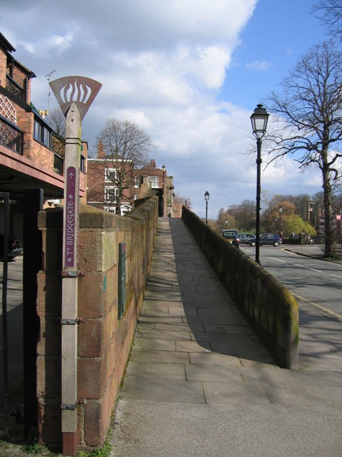
English: Chester's City Walls - Grosvenor Road to Bridgegate #13 This is the sloping approach to the Bridgegate, as indicated by the 'torch' signpost. On the left are some modern apartments and Castle Drive is on the right. Another individual information board, which relates to the old Shipgate, can be seen on the wall to the left - 370740. It is not possible to cross the Bridgegate in a wheelchair, but this ramp does give access to a wide platform from where a good view can be obtained of the Old Dee Bridge and the River Dee. There is also a ramp on the other side of Bridge Street, on the city side of the bridge, for wheelchair users to regain access to the walls. The next photo in this series is taken from the flat platform at the top of the slope.
For the next step see 370068 . |
| Date | |
| Source | From geograph.org.uk |
| Author | John S Turner |
| Attribution (required by the license) | John S Turner / Chester's City Walls - Grosvenor Road to Bridgegate #13 / |
| Camera location | | View this and other nearby images on: OpenStreetMap |
|---|
_heading:45.00&language=en)
| Object location | | View this and other nearby images on: OpenStreetMap |
|---|
_heading:45.00&language=en)
Licensing[edit]

|
This image was taken from the Geograph project collection. See this photograph's page on the Geograph website for the photographer's contact details. The copyright on this image is owned by John S Turner and is licensed for reuse under the Creative Commons Attribution-ShareAlike 2.0 license.
|
This file is licensed under the Creative Commons Attribution-Share Alike 2.0 Generic license.
Attribution: John S Turner
- You are free:
- to share – to copy, distribute and transmit the work
- to remix – to adapt the work
- Under the following conditions:
- attribution – You must give appropriate credit, provide a link to the license, and indicate if changes were made. You may do so in any reasonable manner, but not in any way that suggests the licensor endorses you or your use.
- share alike – If you remix, transform, or build upon the material, you must distribute your contributions under the same or compatible license as the original.
- Remove redundant categories and try to put this image in the most specific category/categories
- Remove this template
- The location categories are based on information from this geonames tool and this OpenStreetMap tool combined with a database. You can also have a look at this tool from mysociety.
- The topic category from Geograph was City walls (find similar images walls at Geograph)
File history
Click on a date/time to view the file as it appeared at that time.
| Date/Time | Thumbnail | Dimensions | User | Comment | |
|---|---|---|---|---|---|
| current | 20:21, 4 January 2011 | | 480 × 640 (157 KB) | GeographBot (talk | contribs) | == {{int:filedesc}} == {{Information |description={{en|1=Chester's City Walls - Grosvenor Road to Bridgegate #13 This is the sloping approach to the Bridgegate, as indicated by the 'torch' signpost. On the left are some modern apartments and Castle Drive |
You cannot overwrite this file.
File usage on Commons
There are no pages that use this file.
File usage on other wikis
The following other wikis use this file:
- Usage on en.wikipedia.org