File:Cholesbury camp map.png
Jump to navigation
Jump to search
No higher resolution available.
Cholesbury_camp_map.png (477 × 353 pixels, file size: 18 KB, MIME type: image/png)
Captions
Captions
Add a one-line explanation of what this file represents
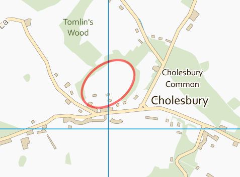
| Description | Map of Cholesbury Camp, Bucks | ||||||
| Date | |||||||
| Source | OS OpenData | ||||||
| Author | Ordnance Survey, with modifications by Prioryman | ||||||
| Permission (Reusing this file) |
|
_(St_Edwards_Crown).svg)
File history
Click on a date/time to view the file as it appeared at that time.
| Date/Time | Thumbnail | Dimensions | User | Comment | |
|---|---|---|---|---|---|
| current | 20:07, 29 January 2012 | | 477 × 353 (18 KB) | Prioryman (talk | contribs) | {{Information |Description=Map of Cholesbury Camp, Bucks |Source=OS OpenData |Date=29 January 2012 |Author=Ordnance Survey, with modifications by Prioryman |Permission= |other_versions= }} Category:Archaeology of Buckinghamshire[[C |
You cannot overwrite this file.
File usage on Commons
There are no pages that use this file.
File usage on other wikis
The following other wikis use this file:
- Usage on en.wikipedia.org