File:Cholsey railway station, Oxfordshire (geograph 6944628).jpg
Jump to navigation
Jump to search

Size of this preview: 800 × 600 pixels. Other resolutions: 320 × 240 pixels | 640 × 480 pixels | 1,024 × 768 pixels | 1,280 × 960 pixels | 1,600 × 1,200 pixels.
Original file (1,600 × 1,200 pixels, file size: 515 KB, MIME type: image/jpeg)
Captions
Captions
Add a one-line explanation of what this file represents
Summary
[edit].jpg&action=edit§ion=1)
| Description |
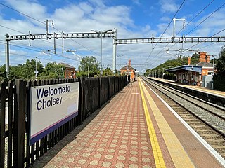
English: Cholsey railway station, Oxfordshire Opened in 1892 by the Great Western Railway on its lines from London to Bristol and Oxford, this station replaced the one at Moulsford which closed at the same time - see SU5985 : Moulsford railway station (site), Oxfordshire. View north west towards Didcot and Oxford, some 5 years after the line was electrified. The 'Mains/fast' lines are to the left[1], behind the fence, which makes them normally inaccessible. The bay platform for Wallingford trains is beyond the building on the right. For a pre-electrification view in the opposite direction, see SU5886 : Cholsey railway station, Oxfordshire, 2004. |
| Date | |
| Source | From geograph.org.uk |
| Author | Nigel Thompson |
| Permission (Reusing this file) |
Creative Commons Attribution Share-alike license 2.0 |
| Attribution (required by the license) | Nigel Thompson / Cholsey railway station, Oxfordshire / |
,_Oxfordshire_(geograph_5648937).jpg)
.jpg)
| Camera location | | View this and other nearby images on: OpenStreetMap |
|---|
.jpg¶ms=051.569941_N_-001.158201_E_globe:Earth_type:camera_source:geograph-osgb36(SU58448601)_heading:315.00&language=en)
| Object location | | View this and other nearby images on: OpenStreetMap |
|---|
.jpg¶ms=051.570300_N_-001.158770_E_globe:Earth_class:object_type:object_source:geograph-osgb36(SU58408605)_heading:315.00&language=en)
Licensing
[edit].jpg&action=edit§ion=2)

|
This image was taken from the Geograph project collection. See this photograph's page on the Geograph website for the photographer's contact details. The copyright on this image is owned by Nigel Thompson and is licensed for reuse under the Creative Commons Attribution-ShareAlike 2.0 license.
|
This file is licensed under the Creative Commons Attribution-Share Alike 2.0 Generic license.
Attribution: Nigel Thompson
- You are free:
- to share – to copy, distribute and transmit the work
- to remix – to adapt the work
- Under the following conditions:
- attribution – You must give appropriate credit, provide a link to the license, and indicate if changes were made. You may do so in any reasonable manner, but not in any way that suggests the licensor endorses you or your use.
- share alike – If you remix, transform, or build upon the material, you must distribute your contributions under the same or compatible license as the original.
File history
Click on a date/time to view the file as it appeared at that time.
| Date/Time | Thumbnail | Dimensions | User | Comment | |
|---|---|---|---|---|---|
| current | 15:06, 14 November 2021 | | 1,600 × 1,200 (515 KB) | Lamberhurst (talk | contribs) | == {{int:filedesc}} == {{Information |Description={{en|1=<b>Cholsey railway station, Oxfordshire</b><br>Opened in 1892 by the Great Western Railway on its lines from London to Bristol and Oxford, this station replaced the one at Moulsford which closed at the same time - see SU5985 : Moulsford railway station (site), Oxfordshire. View north west towards Didcot and Oxford, some 5 years after the line was electrified.... |
You cannot overwrite this file.
File usage on Commons
The following page uses this file:
File usage on other wikis
The following other wikis use this file:
- Usage on en.wikipedia.org
.jpg&oldid=857588928)