File:Citytrain-railway-network-map.png
Jump to navigation
Jump to search
Size of this preview: 330 × 598 pixels. Other resolutions: 132 × 240 pixels | 265 × 480 pixels | 423 × 768 pixels | 565 × 1,024 pixels | 2,500 × 4,533 pixels.
Original file (2,500 × 4,533 pixels, file size: 425 KB, MIME type: image/png)
Captions
Captions
Add a one-line explanation of what this file represents
| Description |
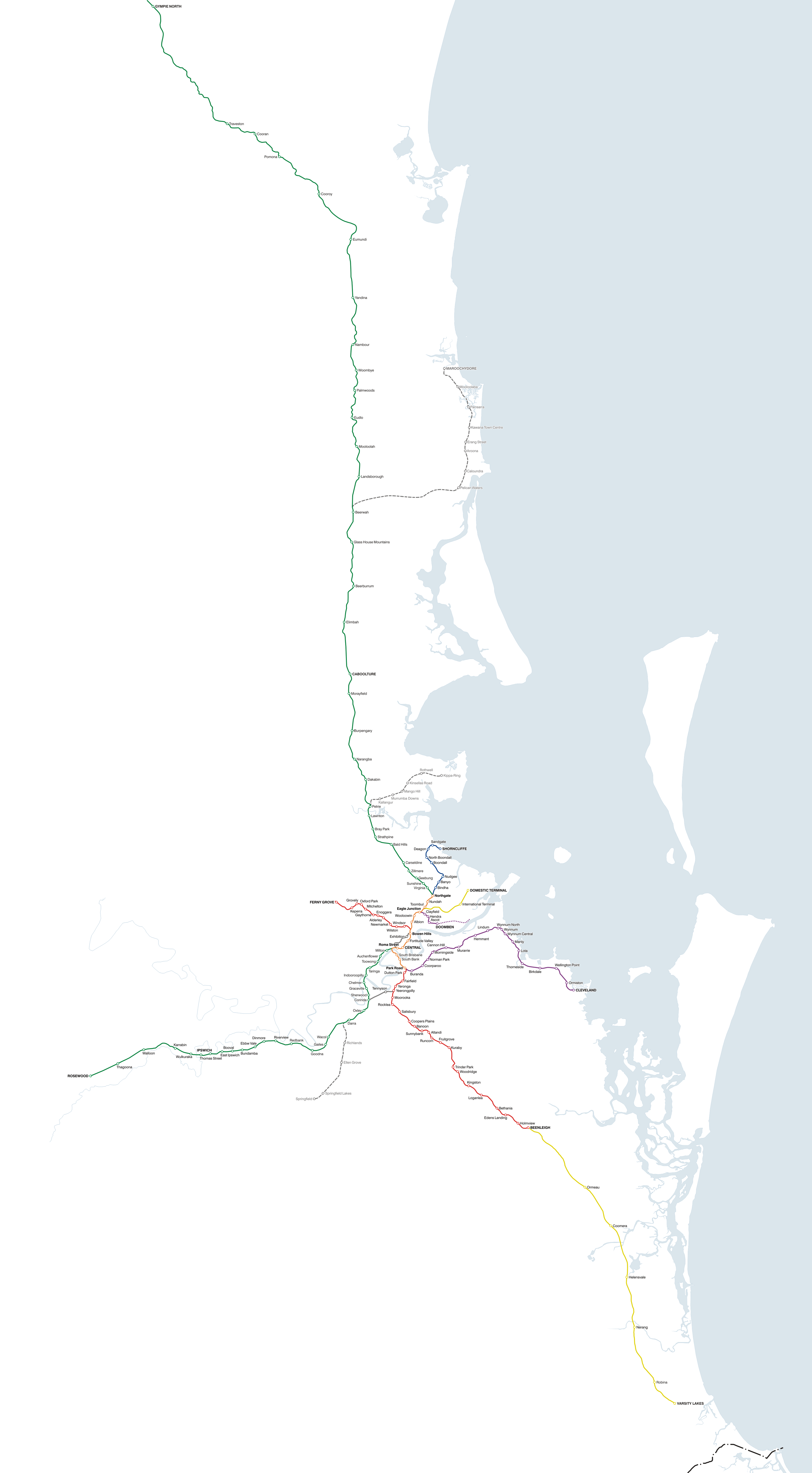
Accurate, to-scale map of the QR Citytrain network, covering South East Queensland, Australia Suburban lines – north of Brisbane Suburban lines – south and west of Brisbane Suburban lines – inner Brisbane Denotes the 'inner' of the network where more than one line shares the route
Interurban lines – north of Brisbane Interurban lines – south and west of Brisbane Proposed or under construction Denotes lines proposed or under construction |
||
| Date | |||
| Source | Own work | ||
| Author | Seo75 | ||
| Permission (Reusing this file) |
This file is licensed under the Creative Commons Attribution-Share Alike 2.1 Australia license.
 I, the copyright holder of this work, hereby publish it under the following licenses:
This file is licensed under the Creative Commons Attribution-Share Alike 3.0 Unported license.
You may select the license of your choice. |
||
| Other versions |


File history
Click on a date/time to view the file as it appeared at that time.
| Date/Time | Thumbnail | Dimensions | User | Comment | |
|---|---|---|---|---|---|
| current | 03:15, 15 December 2009 | | 2,500 × 4,533 (425 KB) | Seo75 (talk | contribs) | Varsity Lakes railway station is now real; minors. |
| 09:09, 22 December 2008 |  | 2,500 × 4,534 (318 KB) | Seo75 (talk | contribs) | {{Information |Description= |Source= |Date= |Author= |Permission= |other_versions= }} | |
| 09:03, 22 December 2008 |  | 2,998 × 5,437 (363 KB) | Seo75 (talk | contribs) | {{Information |Description= |Source= |Date= |Author= |Permission= |other_versions= }} | |
| 03:03, 2 May 2008 |  | 2,000 × 3,625 (152 KB) | Seo75 (talk | contribs) | ||
| 02:13, 10 January 2008 |  | 2,000 × 3,625 (486 KB) | Seo75 (talk | contribs) | ||
| 01:55, 10 January 2008 |  | 2,000 × 3,749 (502 KB) | Seo75 (talk | contribs) | {{Information |Description=Accurate, to-scale map of the QR Citytrain network, covering South East Queensland, Australia '''Suburban lines – north of Brisbane''' {{legend |
You cannot overwrite this file.
File usage on Commons
The following page uses this file:
File usage on other wikis
The following other wikis use this file:
- Usage on de.wikivoyage.org
- Usage on en.wikipedia.org
- Usage on fr.wikipedia.org
- Usage on ja.wikipedia.org
- Usage on pt.wikipedia.org
- Usage on www.wikidata.org