File:Claes Janszoon Visscher II, De Gelegentheyt van't Paradys ende t'Landt Canaan, mitsgaders de eerst bewoonde Landen der Patriarchen (FL199992244 2369110).jpg
Jump to navigation
Jump to search

Size of this preview: 705 × 599 pixels. Other resolutions: 282 × 240 pixels | 565 × 480 pixels | 904 × 768 pixels | 1,205 × 1,024 pixels | 2,410 × 2,048 pixels | 9,864 × 8,384 pixels.
Original file (9,864 × 8,384 pixels, file size: 45.63 MB, MIME type: image/jpeg)
Captions
Captions
Add a one-line explanation of what this file represents
Summary[edit]
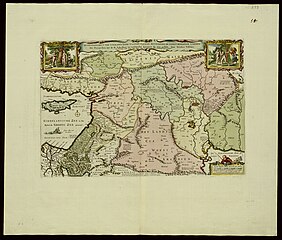
| Claes Janszoon Visscher II: De Gelegentheyt van't Paradys ende t'Landt Canaan, mitsgaders de eerst bewoonde Landen der Patriarchen
( |
||||||||||||||||||||||||
|---|---|---|---|---|---|---|---|---|---|---|---|---|---|---|---|---|---|---|---|---|---|---|---|---|
| Artist |
| |||||||||||||||||||||||
| Contributors | Visscher, Nicolaes, 1618-1679 Broeck, Abraham van den | |||||||||||||||||||||||
| Title |
De Gelegentheyt van't Paradys ende t'Landt Canaan, mitsgaders de eerst bewoonde Landen der Patriarchen |
|||||||||||||||||||||||
| Description |
De Gelegentheyt van't Paradys ende t'Landt Canaan, mitsgaders de eerst bewoonde Landen der Patriarchen. uyt de H.Schrifture en verscheyden auctoren by een gestelt . door Nicolaes Visscher. Broeck sculpsit. |
|||||||||||||||||||||||
| Language | Dutch | |||||||||||||||||||||||
| Publication date | 1660 possibly | |||||||||||||||||||||||
| Dimensions | 313 × 469 mm (12.32 × 18.46 in) | |||||||||||||||||||||||
| Collection |
|
|||||||||||||||||||||||
| Current location |
|
|||||||||||||||||||||||
| Place of publication | Amsterdam | |||||||||||||||||||||||
| search Merhav catalog | Amsterdam | |||||||||||||||||||||||
| Notes | בפינה ימנית תחתונה סמל בית ההוצאה: דייגים עם כלי דיג - רשת, חכה.; Copperplate; The map is an enlarged-scale copy of the 1645 edition, with wome changes.; From a Dutch Bible. Dese Kaerte wert gestelt voor het 3en cap. Genesis | |||||||||||||||||||||||
| IE PID | IE199992240 | |||||||||||||||||||||||
| Rosetta filename | FL199992244 | |||||||||||||||||||||||
| NNL item ID (P3959) | 990023691100205171 | |||||||||||||||||||||||
| search Merhav catalog | Dutch, Claes Janszoon Visscher II | |||||||||||||||||||||||
| Source/Photographer |
|
|||||||||||||||||||||||
| Other versions | ||||||||||||||||||||||||
| Jpg / Tif version |
|
|||||||||||||||||||||||

.jpg)

.jpg&action=edit§ion=1)
Licensing[edit]
.jpg&action=edit§ion=2)
The copyright situation of this work is theoretically uncertain, because in the country of origin copyright lasts 70 years after the death of the author, and the date of the author's death is unknown. However, the date of creation of the work was over 120 years ago, and it is thus a reasonable assumption that the copyright has expired (see here for the community discussion). Do not use this template if the date of death of the author is known.
| |
| This file has been identified as being free of known restrictions under copyright law, including all related and neighboring rights. | |
File history
Click on a date/time to view the file as it appeared at that time.
| Date/Time | Thumbnail | Dimensions | User | Comment | |
|---|---|---|---|---|---|
| current | 02:02, 29 July 2023 | | 9,864 × 8,384 (45.63 MB) | Geagea (talk | contribs) | pattypan 22.03 |
You cannot overwrite this file.
File usage on Commons
The following page uses this file:
.jpg&oldid=861627235)