File:Cold War-1970.png
Jump to navigation
Jump to search
Size of this preview: 800 × 370 pixels. Other resolutions: 320 × 148 pixels | 640 × 296 pixels | 1,357 × 628 pixels.
Original file (1,357 × 628 pixels, file size: 57 KB, MIME type: image/png)
Captions
Captions
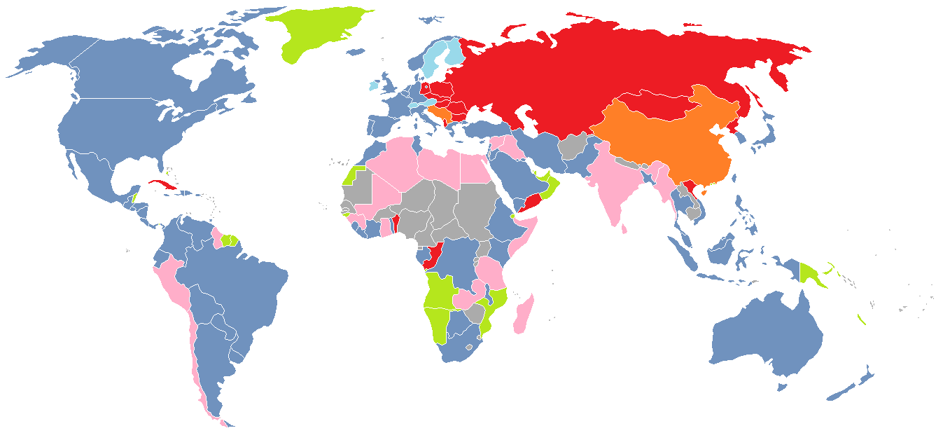
The main areas of Cold War 1962 - 1979
Summary[edit]
| Description |
English: A color-coded map of the world in 1970, showing various groups of countries depending on their position in the Cold War
Français : Carte du monde montrant par un code couleur les alliances en 1970 pendant la Guerre Froide
Русский: Политическая карта мира на 1970 год, показывающая отношение стран к противникам Холодной войны
Latviešu: Pasaules politiskā karte uz 1970. gadu, kas parāda valstu nostāju Aukstā kara laikā
|
| Date | |
| Source | Own work |
| Author | J_intela (talk) (Uploads) |
Licensing[edit]
| This work has been released into the public domain by its author, J intela at English Wikipedia. This applies worldwide. In some countries this may not be legally possible; if so: J intela grants anyone the right to use this work for any purpose, without any conditions, unless such conditions are required by law. |
Original upload log[edit]
The original description page was here. All following user names refer to en.wikipedia.
| Date/Time | Dimensions | User | Comment |
|---|---|---|---|
| 2012-07-10 17:09 | 1357×628× (58145 bytes) | J intela | Fixed Guyana and Jamaca |
| 2012-07-09 19:26 | 1357×628× (58146 bytes) | J intela | Forgot Malawi |
| 2012-07-09 19:23 | 1357×628× (58150 bytes) | J intela | Forgot Farro Islands |
| 2012-07-09 19:15 | 1357×628× (58174 bytes) | J intela | A thorough map of the cold war in the world in 1970 |
File history
Click on a date/time to view the file as it appeared at that time.
| Date/Time | Thumbnail | Dimensions | User | Comment | |
|---|---|---|---|---|---|
| current | 01:15, 23 February 2015 | | 1,357 × 628 (57 KB) | BD2412 (talk | contribs) | Transferred from en.wikipedia |
You cannot overwrite this file.
File usage on Commons
There are no pages that use this file.
File usage on other wikis
The following other wikis use this file:
- Usage on en.wikipedia.org
- Usage on fr.wikipedia.org
- Usage on hu.wikipedia.org
- Usage on id.wikipedia.org
- Usage on ru.wikipedia.org
- Usage on uk.wikipedia.org
- Usage on zh.wikipedia.org