File:ColonialAfrica.png
Jump to navigation
Jump to search
No higher resolution available.
ColonialAfrica.png (282 × 325 pixels, file size: 8 KB, MIME type: image/png)
Captions
Captions
Add a one-line explanation of what this file represents
Summary
[edit]
|
File:Colonial Africa 1913 map.svg is a vector version of this file. It should be used in place of this PNG file.
File:ColonialAfrica.png → File:Colonial Africa 1913 map.svg
For more information, see Help:SVG. |
 |
| Description |
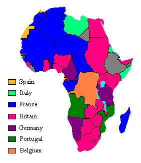
English: Map showing European claimants to the African continent in 1913 |
| Date | (first version); 15 August 2004 |
| Source | Transferred from en.wikipedia to Commons. |
| Author | The original uploader was Aris Katsaris at English Wikipedia. |
| Other versions |
[]
|


.svg)

_ast.svg)


-es.svg)
_mapa.png)

_eu.svg)


.svg)

.jpg)


-sr.png)


.svg)


.svg)

Licensing
[edit]
| This file is licensed under the Creative Commons Attribution-Share Alike 3.0 Unported license. Subject to disclaimers. | ||
| ||
| This licensing tag was added to this file as part of the GFDL licensing update. |

|
Permission is granted to copy, distribute and/or modify this document under the terms of the GNU Free Documentation License, Version 1.2 or any later version published by the Free Software Foundation; with no Invariant Sections, no Front-Cover Texts, and no Back-Cover Texts. A copy of the license is included in the section entitled GNU Free Documentation License. Subject to disclaimers. |
Original upload log
[edit]
The original description page was here. All following user names refer to en.wikipedia.
- 2004-10-10 21:37 SimonP 276×323× (7068 bytes) tweaks
- 2004-10-10 19:01 SimonP 276×323× (7219 bytes) coorect and error
- 2004-08-15 10:00 Aris Katsaris 276×347× (8476 bytes) Turned [[:Image:Colafrica.jpg]] of [[User:J.J.]] into png which is a more proper format for this.
File history
Click on a date/time to view the file as it appeared at that time.
| Date/Time | Thumbnail | Dimensions | User | Comment | |
|---|---|---|---|---|---|
| current | 02:17, 1 November 2021 | | 282 × 325 (8 KB) | Randomastwritter (talk | contribs) | jubaland |
| 03:03, 20 April 2005 |  | 276 × 323 (7 KB) | Yonghokim (talk | contribs) | Map showing European claimants to the African continent in 1913 Drawn by en:User:J.J. and transformed by en:User:Aris Katsaris to .png format. {{GFDL}} |
You cannot overwrite this file.
File usage on Commons
The following 48 pages use this file:
- User:Minorax/SVG available/2021 November 1-6
- File:Africa1913 fr.png
- File:Africa Colonial.png
- File:Africa colonization 1914.PNG
- File:Africacolony.PNG
- File:African colonization map (swedish).jpg
- File:Afrika 1913.png
- File:Afrika 1914.png
- File:Afrika 1914 - sr.png
- File:Afrika Kolonisation Farben.png
- File:Afrika koloniala 1914an.png
- File:ColonialAfrica-da.png
- File:ColonialAfrica-no.png
- File:ColonialAfrica.png
- File:ColonialAfrica Zh.PNG
- File:Colonial Africa 1800 map.png
- File:Colonial Africa 1870 map-fr.png
- File:Colonial Africa 1870 map.png
- File:Colonial Africa 1900 map-fr.png
- File:Colonial Africa 1900 map.png
- File:Colonial Africa 1913, pre WWI-es.svg
- File:Colonial Africa 1913, pre WWI.svg
- File:Colonial Africa 1913 map.svg
- File:Colonial Africa 1914 map-he.png
- File:Colonial Africa 1914 map.png
- File:Colonial Africa 1923 map.png
- File:Colonias en Africa (1914) mapa.png
- File:Colonies in Africa in 1914.jpg
- File:Decolonization of Africa PL.PNG
- File:FeizhouZhimindi.png
- File:Hui-chiu sit-bin-te 1914.png
- File:Kolonie Afryka 1947.PNG
- File:Kolonie afryka 1914.PNG
- File:Kolonien-Afrikas.svg
- File:Kolonisation Afrikas.png
- File:Map of Africa in 1939.png
- File:Map of Colonial Africa (1914)-sr.png
- File:Mapa del África colonial (1914).svg
- File:Mapa del África colonial (1914) ast.svg
- File:Mapa del África colonial (1914) eu.svg
- File:Mapa del África colonial (1939).svg
- File:Mapa del África colonial (1947).svg
- File:Mapa mudo del África colonial (1914).svg
- File:Mapa polityczna Afryki (1914)-es.svg
- File:Mapa polityczna Afryki (1914).svg
- File:ΑποικιακήΑφρική.png
- File:Колонии на Африка през 1914.png
- Template:Other versions/Colonial Africa
.svg)
File usage on other wikis
The following other wikis use this file:
- Usage on din.wikipedia.org
- Usage on en.wikipedia.org
- Usage on fa.wikipedia.org
- Usage on hr.wikipedia.org
- Usage on it.wikipedia.org
- Usage on jv.wikipedia.org
- Usage on ka.wikipedia.org
- Usage on kk.wikipedia.org
- Usage on pnb.wikipedia.org
- Usage on ru.wikipedia.org
- Usage on sd.wikipedia.org
- Usage on ur.wikipedia.org