File:Columbia Hills (Infrared View) - Mars Reconnaissance Orbiter (50524267953).png

Original file (1,821 × 1,821 pixels, file size: 16.6 MB, MIME type: image/png)
Captions
Captions
Summary[edit]
| DescriptionColumbia Hills (Infrared View) - Mars Reconnaissance Orbiter (50524267953).png |
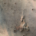
False color infrared image of the Columbia Hills in Gusev Crater. This region was explored by the Spirit rover between 2004 to 2010. The mission landing site was chosen with the expectation that the flat terrain of Gusev Crater were sediments deposited in a lake fed by Ma'adim Vallis, a large canyon system that empties into Gusev. However, it became clear soon after landing that the crater is filled by a vast lava plain. Although lake sediments are probably present in Gusev, they are buried by these lava flows. A greater of diversity of rocks were seen in the Columbia Hills, many of which appeared to be sedimentary and volcaniclastic rocks. This has led some researchers to suggest that the Columbia Hills represent an exposure of lakebed sediments that were folded towards the surface along a thrust fault (one of several in Gusev). Images of rocks in the visible range of the spectrum (380-780 nm) usually show very small changes in color. However, rocks are much more colorful in the 1000 nm to 2600 nm range due to the presence of strong absorption features related to common transition metals (such as iron) in mineral crystals. These differences help highlight the difference between the relatively bland rocks of the Gusev lava plains and the more compositionally diverse rocks exposed in the Columbia Hills. This false color was created using the CRISM imaging spectrometer. Each pixel of a CRISM image contains a 500 point spectrum, from which a color can be reconstructed. This reconstructed color was overlaid on a higher-resolution image taken with the Mars Reconnaissance Orbiter Context Camera (CTX), which simultaneously took a photo while CRISM was collecting data. This image wast taken on December 12, 2006. It uses CRISM observation FRT000035d0 and CTX observation P02_001777_1653_XI_14S184W. Image Credit: NASA / JPL / JHUAPL / MSSS / Justin Cowart |
| Date | |
| Source | Columbia Hills (Infrared View) - Mars Reconnaissance Orbiter |
| Author | Justin Cowart |
Licensing[edit]
| Public domainPublic domainfalsefalse |
| This file is in the public domain in the United States because it was solely created by NASA. NASA copyright policy states that "NASA material is not protected by copyright unless noted". (See Template:PD-USGov, NASA copyright policy page or JPL Image Use Policy.) |  | |
 |
Warnings:
|
- You are free:
- to share – to copy, distribute and transmit the work
- to remix – to adapt the work
- Under the following conditions:
- attribution – You must give appropriate credit, provide a link to the license, and indicate if changes were made. You may do so in any reasonable manner, but not in any way that suggests the licensor endorses you or your use.
| This image was originally posted to Flickr by jccwrt at https://flickr.com/photos/132160802@N06/50524267953. It was reviewed on 3 December 2020 by FlickreviewR 2 and was confirmed to be licensed under the terms of the cc-by-2.0. |
3 December 2020
File history
Click on a date/time to view the file as it appeared at that time.
| Date/Time | Thumbnail | Dimensions | User | Comment | |
|---|---|---|---|---|---|
| current | 12:03, 3 December 2020 |  | 1,821 × 1,821 (16.6 MB) | Eyes Roger (talk | contribs) | Transferred from Flickr via #flickr2commons |
You cannot overwrite this file.
File usage on Commons
There are no pages that use this file.
Metadata
This file contains additional information such as Exif metadata which may have been added by the digital camera, scanner, or software program used to create or digitize it. If the file has been modified from its original state, some details such as the timestamp may not fully reflect those of the original file. The timestamp is only as accurate as the clock in the camera, and it may be completely wrong.
| Software used | Adobe Photoshop 21.0 (Windows) |
|---|---|
| Date and time of digitizing | 18:11, 19 October 2020 |
| File change date and time | 13:24, 20 October 2020 |
| Date metadata was last modified | 13:24, 20 October 2020 |
| Unique ID of original document | xmp.did:71f95af2-cec5-3943-a655-6d65b310ef57 |
| Horizontal resolution | 28.35 dpc |
| Vertical resolution | 28.35 dpc |