File:Copernicus EMS Activation EMSR177 - Amatrice Aerial, Grading Map, Aug 2016.jpg
Jump to navigation
Jump to search

Size of this preview: 800 × 565 pixels. Other resolutions: 320 × 226 pixels | 640 × 452 pixels | 1,024 × 723 pixels | 1,280 × 904 pixels | 2,560 × 1,808 pixels | 3,311 × 2,339 pixels.
Original file (3,311 × 2,339 pixels, file size: 1.31 MB, MIME type: image/jpeg)
Captions
Captions
Add a one-line explanation of what this file represents
Summary[edit]
| Description |
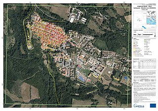
English: Copernicus Emergency Management Service Activation [EMSR177] Amatrice Aerial: Grading Map 1:1000 |
||
| Date | |||
| Source | http://emergency.copernicus.eu/EMSR177 | ||
| Author | © European Union | ||
| Permission (Reusing this file) |
|
Licensing[edit]
European Union, the copyright holder of this work, hereby publishes it under the following licenses:

|
Permission is granted to copy, distribute and/or modify this document under the terms of the GNU Free Documentation License, Version 1.2 or any later version published by the Free Software Foundation; with no Invariant Sections, no Front-Cover Texts, and no Back-Cover Texts. A copy of the license is included in the section entitled GNU Free Documentation License. |
This file is licensed under the Creative Commons Attribution-Share Alike 3.0 Unported license.
Attribution: European Union
- You are free:
- to share – to copy, distribute and transmit the work
- to remix – to adapt the work
- Under the following conditions:
- attribution – You must give appropriate credit, provide a link to the license, and indicate if changes were made. You may do so in any reasonable manner, but not in any way that suggests the licensor endorses you or your use.
- share alike – If you remix, transform, or build upon the material, you must distribute your contributions under the same or compatible license as the original.
You may select the license of your choice.
Original upload log[edit]
The original description page was here. All following user names refer to en.wikipedia.
| Date/Time | Dimensions | User | Comment |
|---|---|---|---|
| 2018-10-12 02:31:32 | 3311 × 2339 | O.dvorak | Copernicus Emergency Management Service Activation [EMSR177] Amatrice Aerial: Grading Map 1:1000, Published: 2016-08-31 13:36:07 (UTC) |
File history
Click on a date/time to view the file as it appeared at that time.
| Date/Time | Thumbnail | Dimensions | User | Comment | |
|---|---|---|---|---|---|
| current | 11:28, 31 October 2018 | | 3,311 × 2,339 (1.31 MB) | Junior Jumper (talk | contribs) | Transferred from en.wikipedia (MTC!) (1.1.0) |
You cannot overwrite this file.
File usage on Commons
There are no pages that use this file.