File:Croatia of Tomislav-slo.PNG
Jump to navigation
Jump to search

Size of this preview: 800 × 597 pixels. Other resolutions: 320 × 239 pixels | 640 × 477 pixels | 901 × 672 pixels.
Original file (901 × 672 pixels, file size: 154 KB, MIME type: image/png)
Captions
Captions
Add a one-line explanation of what this file represents
| Description |
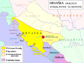
English: Map of Croatia during the last years of Tomislav's reign. This map is based on the written sources in: 1. Klaić (1990). Pages 72-74- for descriptions of Slavonia region and Bulgarians; 2. Goldstein (2008). Pages 37-38- for descriptions Slavonia region and Bulgarians; 3. Voje (1994). Page 54 for Slavonia region, page 68 for Bulgarians, pages 79-81 for description of serbian lands; 4. Štih Peter (2001). Ozemlje Slovenije v zgodnjem srednjem veku. Ljubljana, Filozofska fakulteta. Page 82 for description of slovenian lands after Hungarian conquest. For retrospective approach look at the map f Hungary at the and of 11th century- in 1. Kontler Laszlo (2005): Madžarska zgodovina. Ljubljana, Slovenska matica. Page 65. |
| Date | (UTC) |
| Source | |
| Author |
|
| This is a retouched picture, which means that it has been digitally altered from its original version. Modifications: Part of the map was used to create a new historical map.. The original can be viewed here: Waterways of SE Central Europe.svg:
|
I, the copyright holder of this work, hereby publish it under the following license:
| I, the copyright holder of this work, release this work into the public domain. This applies worldwide. In some countries this may not be legally possible; if so: I grant anyone the right to use this work for any purpose, without any conditions, unless such conditions are required by law. |
Original upload log[edit]
This image is a derivative work of the following images:
- File:Waterways_of_SE_Central_Europe.svg licensed with PD-self
- 2010-01-08T20:49:27Z Kmiki87 1415x1059 (292577 Bytes) {{Information |Description={{en|1=Waterways along the central and lower Danube, including the Bohemian and Carpathian Basins, the northern Balkans, parts of Austria, southern Poland and Western Ukraine.}} |Source={{own}} |Aut
Uploaded with derivativeFX
File history
Click on a date/time to view the file as it appeared at that time.
| Date/Time | Thumbnail | Dimensions | User | Comment | |
|---|---|---|---|---|---|
| current | 14:52, 20 February 2022 | | 901 × 672 (154 KB) | Luigimini (talk | contribs) | There were no "mixed influences". Slavonia was croatian since Tomislav beat the Hungarians in 925. Vassals. https://upload.wikimedia.org/wikipedia/hr/1/1b/Tomislavova_Hrvatska.jpg |
| 14:24, 20 February 2022 |  | 901 × 672 (161 KB) | Luigimini (talk | contribs) | This map is based on unreliable and sources that display croatia in a different time period. Mainstream historiography agrees with the map of Ferdo Šišić, Stjepan Srkulja and other 20th cent. croatian historians (see: https://upload.wikimedia.org/wikipedia/hr/thumb/1/1b/Tomislavova_Hrvatska.jpg/800px-Tomislavova_Hrvatska.jpg) Kotor was under Byzantium, Serbian areas are more eastern, hum trabunia and dioclea were vassal states of Croatia. Slavonia was constantly croatian since Tomislav beat t... | |
| 16:31, 16 August 2010 |  | 901 × 672 (120 KB) | Bostjan46 (talk | contribs) | The region of Dioclea has no reliable data- the supremacy of Byzantium has been put under the question. | |
| 13:04, 15 August 2010 |  | 901 × 672 (120 KB) | Bostjan46 (talk | contribs) | {{Information |Description={{en|1=Map of Croatia during the last years of Tomislav's reign. This map is based on the '''maps''' of 1. Klaić Nada (1990). ''Povijest Hrvata u srednjem vijeku''. Zagreb, Globus. Painted on Cover; 2. Voje Ignacij (1994). '' |
You cannot overwrite this file.
File usage on Commons
The following 2 pages use this file:
File usage on other wikis
The following other wikis use this file:
- Usage on sh.wikipedia.org
- Usage on sl.wikipedia.org