File:Cross of Sacrifice - geograph.org.uk - 752872.jpg
Jump to navigation
Jump to search

Size of this preview: 450 × 600 pixels. Other resolutions: 180 × 240 pixels | 480 × 640 pixels.
Original file (480 × 640 pixels, file size: 111 KB, MIME type: image/jpeg)
Captions
Captions
Add a one-line explanation of what this file represents
Summary[edit]
| Description |
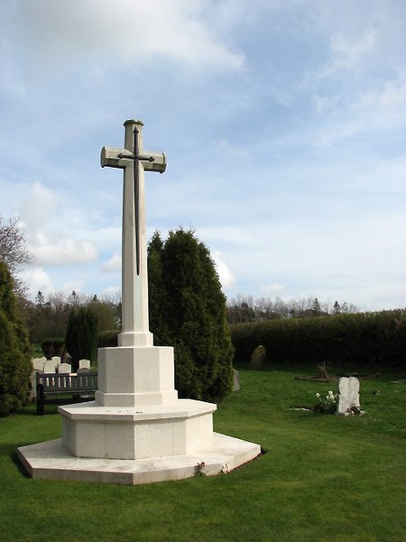
English: Cross of Sacrifice. On the edge of ex-RAF Coltishall (the last surviving operational RAF airbase from WWII, closed in 2006), surrounded by fields still accommodating the now redundant landing aids, ground was set aside by the Scottow Parish Council for burials from the station in 1939. Closed again in 1943 due to a shortage of space, nearly 60 casualties of various nationalities are commemorated on the site. After the war a Cross of Sacrifice (seen here) was erected in the eastern section of the plot. A tiny, brick-built cemetery chapel stands not far distant from the entrance > 752863. A red light to alert aircraft to its existence is still affixed to its roof. |
| Date | |
| Source | From geograph.org.uk |
| Author | Evelyn Simak |
| Attribution (required by the license) | Evelyn Simak / Cross of Sacrifice / |
| Camera location | | View this and other nearby images on: OpenStreetMap |
|---|
_heading:112.00&language=en)
| Object location | | View this and other nearby images on: OpenStreetMap |
|---|
_heading:112.00&language=en)
Licensing[edit]

|
This image was taken from the Geograph project collection. See this photograph's page on the Geograph website for the photographer's contact details. The copyright on this image is owned by Evelyn Simak and is licensed for reuse under the Creative Commons Attribution-ShareAlike 2.0 license.
|
This file is licensed under the Creative Commons Attribution-Share Alike 2.0 Generic license.
Attribution: Evelyn Simak
- You are free:
- to share – to copy, distribute and transmit the work
- to remix – to adapt the work
- Under the following conditions:
- attribution – You must give appropriate credit, provide a link to the license, and indicate if changes were made. You may do so in any reasonable manner, but not in any way that suggests the licensor endorses you or your use.
- share alike – If you remix, transform, or build upon the material, you must distribute your contributions under the same or compatible license as the original.
File history
Click on a date/time to view the file as it appeared at that time.
| Date/Time | Thumbnail | Dimensions | User | Comment | |
|---|---|---|---|---|---|
| current | 14:39, 19 February 2011 | | 480 × 640 (111 KB) | GeographBot (talk | contribs) | == {{int:filedesc}} == {{Information |description={{en|1=Cross of Sacrifice On the edge of ex-RAF Coltishall (the last surviving operational RAF airbase from WWII, closed in 2006), surrounded by fields still accommodating the now redundant landing aids, g |
You cannot overwrite this file.
File usage on Commons
The following 2 pages use this file:
File usage on other wikis
The following other wikis use this file:
- Usage on www.wikidata.org