File:Cuenca del Apure.jpg
Jump to navigation
Jump to search

Size of this preview: 800 × 526 pixels. Other resolutions: 320 × 210 pixels | 640 × 421 pixels | 1,024 × 673 pixels | 1,280 × 841 pixels | 2,097 × 1,378 pixels.
Original file (2,097 × 1,378 pixels, file size: 684 KB, MIME type: image/jpeg)
Captions
Captions
Add a one-line explanation of what this file represents
Summary[edit]
| Description |
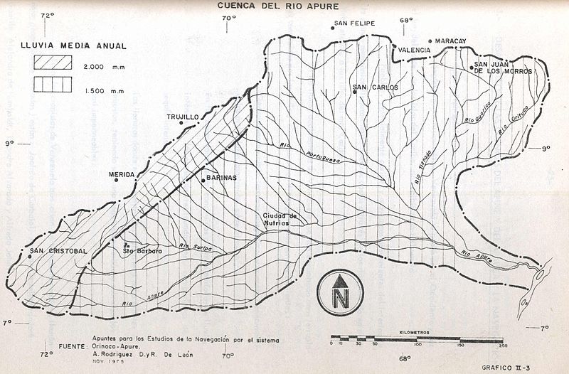
English: Apure River Basin
Español: Cuenca del río Apure. Cartograma elaborado por el Ingeniero Alberto J. Rodríguez Díaz que se incluyó en la obra Desarrollo del eje de navegación Orinoco - Apure - Arauca. Informe preliminar, Volumen I. Caracas: Ministerio del Ambiente y de los Recursos Naturales Renovables, 1980, p. 24, obra mimeografiada de libre divulgación (Uncopyrighted edition) |
| Date | |
| Source | Cuenca del Apure |
| Author | Alberto J. Rodríguez Díaz |
| Permission (Reusing this file) |
Public domain |
Licensing[edit]
I, the copyright holder of this work, hereby publish it under the following licenses:

|
Permission is granted to copy, distribute and/or modify this document under the terms of the GNU Free Documentation License, Version 1.2 or any later version published by the Free Software Foundation; with no Invariant Sections, no Front-Cover Texts, and no Back-Cover Texts. A copy of the license is included in the section entitled GNU Free Documentation License. |
This file is licensed under the Creative Commons Attribution-Share Alike 3.0 Unported license.
- You are free:
- to share – to copy, distribute and transmit the work
- to remix – to adapt the work
- Under the following conditions:
- attribution – You must give appropriate credit, provide a link to the license, and indicate if changes were made. You may do so in any reasonable manner, but not in any way that suggests the licensor endorses you or your use.
- share alike – If you remix, transform, or build upon the material, you must distribute your contributions under the same or compatible license as the original.
You may select the license of your choice.
File history
Click on a date/time to view the file as it appeared at that time.
| Date/Time | Thumbnail | Dimensions | User | Comment | |
|---|---|---|---|---|---|
| current | 02:01, 29 July 2014 | | 2,097 × 1,378 (684 KB) | Fev (talk | contribs) | {{Information |Description ={{en|1=Apure River Basin}} {{es|1=Cuenca del río Apure. Cartograma elaborado por el Ingeniero Alberto J. Rodríguez Díaz que se incluyó en la obra ''Desarrollo del eje de navegación Orinoco - Apure - Arauca''. Informe... |
You cannot overwrite this file.
File usage on Commons
There are no pages that use this file.
File usage on other wikis
The following other wikis use this file:
- Usage on bg.wikipedia.org
- Usage on es.wikipedia.org
- Usage on ru.wikipedia.org
- Usage on sh.wikipedia.org