File:Curiosity Mars Rover's Route from Landing to 'The Kimberley' Waypoint.jpg

Original file (3,300 × 2,550 pixels, file size: 1.17 MB, MIME type: image/jpeg)
Captions
Captions
Summary[edit]
| DescriptionCuriosity Mars Rover's Route from Landing to 'The Kimberley' Waypoint.jpg |
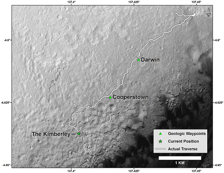
English: Curiosity Mars Rover's Route from Landing to 'The Kimberley' Waypoint
This map shows the route driven by NASA's Curiosity Mars rover from the "Bradbury Landing" location where it landed in August 2012 (the start of the line in upper right) to a major waypoint called "the Kimberley." The rover reached the Kimberley with a 98-foot (30 meter) drive on the 589th Martian day, or sol, of the rover's work on Mars (April 1, 2014). The Kimberley (formerly called "KMS-9") was selected as a major waypoint for the mission because of the diversity of rock types distinguishable in orbital images, exposed close together at this location in a decipherable geological relationship to each other. The base image for this map is from the High Resolution Imaging Science Experiment (HiRISE) camera on NASA's Mars Reconnaissance Orbiter. North is up. The dark ground south of the rover's route has dunes of dark, wind-blown material at the foot of Mount Sharp. The scale bar at lower right represents one kilometer (0.62 mile). For broader-context images of the area, see http://photojournal.jpl.nasa.gov/catalog/PIA17355 , http://photojournal.jpl.nasa.gov/catalog/PIA16064 and http://photojournal.jpl.nasa.gov/catalog/PIA16058 . NASA's Jet Propulsion Laboratory, a division of the California Institute of Technology, Pasadena, manages the Mars Science Laboratory Project and Mars Reconnaissance Orbiter Project for NASA's Science Mission Directorate, Washington.Polski: Trasa łazika Curiosity z miejsca lądowania do punktu kontrolnego 'Kimberley'
Mapa pokazuje trasę należącego do NASA marsjańskiego łazika Curiosity od punktu lądowania "Bradbury Landing" w sierpniu 2012 (początek lini w górnym prawym rogu) do ważnego punktu kontrolnego nazywanego "Kimberley." Łazik dotarł do Kimberley pokonując etap o długości 30 metrów w 589 marsjańskim dniu jego misji na Marsie (1 kwietnia 2014). Kimberley (poprzednio nazywany "KMS-9") został wybrany jako ważny punkt za względu z powodu występującej tutaj dużej różnorodności skał rozróżnialnych z orbity. Bazowy obraz wykorzystany na tej fotografii pochodzi z instrumentu HiRISE umieszczonym na należącym do NASA orbiterze Mars Reconnaissance Orbiter. Północ jest na górze. Ciemne podłoże na przyszłej trasie łazika w dolnych skarpach Mount Sharp jest materiałem nawianym przez wiatr. Należący do NASA Jet Propulsion Laboratory (JPL), będący wydziałem California Institute of Technology w Pasadenie, kieruje projektem Mars Science Laboratory dla należącego do NASA Science Mission Directorate w Waszyngtonie. JPL zaprojektował i zbudował łazik Curiosity. |
| Date | 06.04.2014 |
| Source | http://www.nasa.gov/jpl/msl/pia18076/ |
| Author | NASA |
Licensing[edit]
| Public domainPublic domainfalsefalse |
| This file is in the public domain in the United States because it was solely created by NASA. NASA copyright policy states that "NASA material is not protected by copyright unless noted". (See Template:PD-USGov, NASA copyright policy page or JPL Image Use Policy.) |  | |
 |
Warnings:
|
| Annotations InfoField | This image is annotated: View the annotations at Commons |
File history
Click on a date/time to view the file as it appeared at that time.
| Date/Time | Thumbnail | Dimensions | User | Comment | |
|---|---|---|---|---|---|
| current | 22:55, 5 April 2014 |  | 3,300 × 2,550 (1.17 MB) | Romkur (talk | contribs) | {{Information |Description=Curiosity Mars Rover's Route from Landing to 'The Kimberley' Waypoint This map shows the route driven by NASA's Curiosity Mars rover from the "Bradbury Landing" location where it landed in August 2012 (the start of the line i... |
You cannot overwrite this file.
File usage on Commons
The following 3 pages use this file:
File usage on other wikis
The following other wikis use this file:
- Usage on pl.wikipedia.org