File:Czech Socialist Republic.png
Jump to navigation
Jump to search

Size of this preview: 800 × 460 pixels. Other resolutions: 320 × 184 pixels | 809 × 465 pixels.
Original file (809 × 465 pixels, file size: 16 KB, MIME type: image/png)
Captions
Captions
Add a one-line explanation of what this file represents
Summary[edit]
| Description |
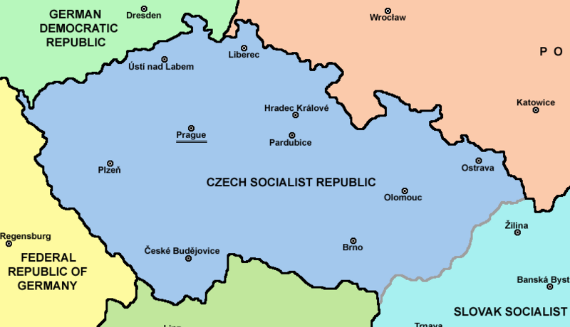
English: Map of Czechoslovakia in 1969-1990 |
| Source | Own work |
| Author | PANONIAN |
| Other versions | Derivative works of this file: |

Licensing[edit]
| |
This work has been released into the public domain by its author, PANONIAN, at the English Wikipedia project. This applies worldwide. In case this is not legally possible: |
References[edit]
Main reference:
- Map is created according to this external source: http://www.tcnj.edu/~guhr2/images/czechoslovakia.jpg archive copy at the Wayback Machine
Secondary references with similar maps:
- http://1.bp.blogspot.com/_Qe1wgxDiEdU/TGti_qWpeYI/AAAAAAAABo0/sSqAfIpQMuU/s1600/1213M_CS.gif
- https://jspivey.wikispaces.com/file/view/T010895A.gif/34419939/T010895A.gif
- http://media.web.britannica.com/eb-media/84/105684-050-0D8412E3.gif archive copy at the Wayback Machine
- http://www.gatheringofisrael.com/atlas/europe/slavic/CS_prague.gif
- http://collections.lib.uwm.edu/agsmap/images/lg/DSCN1455.jpg[dead link]
- http://leccos.com/pics/pic/ceskoslovensko-_mapa_1950.jpg archive copy at the Wayback Machine
- http://www.math.sk/knor/GIF/mapa.gif
- http://ckpaji.sweb.cz/ceskoslovensko.jpg archive copy at the Wayback Machine
- http://www.power.szm.com/historia/mapa_TV_vysielacov_1978.jpg
Secondary references about Geo-political situation - published sources:
- The Times History of Europe, Times Books, London, 2002.
- Richard Overy, The Times History of the 20th Century, Times Books, London, 2004.
- The Times Atlas svjetske povijesti, Cankarjeva založba, Ljubljana - Zagreb, 1986.
- Istorijski atlas, Geokarta, Beograd, 1999.
- Školski istorijski atlas, Zavod za izdavanje udžbenika SR Srbije, Beograd, 1970.
- Povijesni atlas, Učila - Zagreb, Zagreb, 1971.
- Povijesni atlas za osnovnu školu, Kartografija - Tlos, Zagreb, 1975.
- Denis Šehić - Demir Šehić, Istorijski atlas sveta, Beograd, 2007.
Secondary reference about sizable cities:

|
This map image could be re-created using vector graphics as an SVG file. This has several advantages; see Commons:Media for cleanup for more information. If an SVG form of this image is available, please upload it and afterwards replace this template with
{{vector version available|new image name}}.
It is recommended to name the SVG file “Czech Socialist Republic.svg”—then the template Vector version available (or Vva) does not need the new image name parameter. |
The production, editing or release of this file was supported by the Community-Budget of Wikimedia Deutschland. To see other files made with the support of Wikimedia Deutschland, please see the category Supported by Wikimedia Deutschland. |
File history
Click on a date/time to view the file as it appeared at that time.
| Date/Time | Thumbnail | Dimensions | User | Comment | |
|---|---|---|---|---|---|
| current | 08:01, 9 December 2022 | | 809 × 465 (16 KB) | MS Sakib (talk | contribs) | File:Czechoslovakia.png cropped 32 % horizontally, 23 % vertically using CropTool with precise mode. |
You cannot overwrite this file.
File usage on Commons
The following 2 pages use this file:
- File:Czechoslovakia.png
- File:Czechoslovakia (cropped).png (file redirect)
.png&redirect=no)