File:D-A-Independent inter-city rail.png
Jump to navigation
Jump to search

Size of this preview: 517 × 600 pixels. Other resolutions: 207 × 240 pixels | 414 × 480 pixels | 662 × 768 pixels | 882 × 1,024 pixels | 1,814 × 2,105 pixels.
Original file (1,814 × 2,105 pixels, file size: 1.21 MB, MIME type: image/png)
Captions
Captions
Add a one-line explanation of what this file represents
Summary[edit]
| Description |
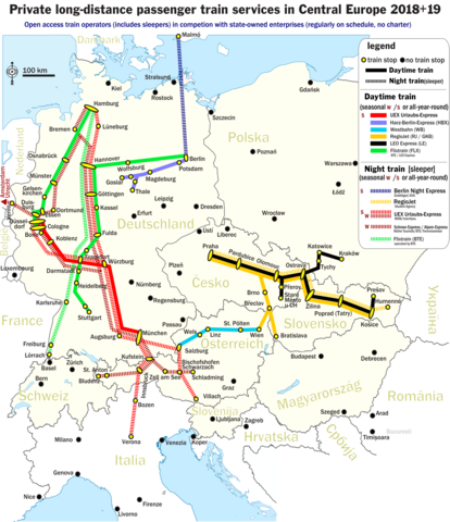
English: The map shows lines of regularly operated long-distance / inter-city passenger rail services from or to destinations in Central Europe. The open-access passenger rail services are self-sufficient and run by privately owned railway companies for profit. The rail services are being run in competition with public-sector (i.e. public body or state-owned) passenger railway companies. Companies being fully or by majority owned by the public sector are excluded from the map (as an example, Arriva plc is 100% owned by German state-owned rail company DB AG and operating all over Europe except Germany - this DB AG passenger rail company and all of its subsidiaries in which Arriva holds the majority are excluded from the map). Also excluded from the map are (i.) rail charters, (ii.) motorail services without the possibility to travel without car or motorbike and also (iii.) long-distance passenger rail services that are procured through public bodies and financed through franchise contracts (no self-sufficient operation) - plus finally (iv.) short-distance services (like shuttles, commuter trains, metros, etc...) of any kind. The map includes all-year round daylight services as well as seasonal / all-year night trains. The operation frequency covers everything between a mimimum of one connection per week up to multiple connections each day (even in the case of seasonal offers). The map shows - in different colors - the different railway lines. Branched railway lines share the same colour as their parent line. For more details, see the legend. |
| Date | |
| Source | Own work |
| Author | Metrancya |
| Other versions | D-A-Wettbewerber-EVU.png (geman-language version of this map) |
Licensing[edit]
I, the copyright holder of this work, hereby publish it under the following license:
This file is licensed under the Creative Commons Attribution 4.0 International license.
- You are free:
- to share – to copy, distribute and transmit the work
- to remix – to adapt the work
- Under the following conditions:
- attribution – You must give appropriate credit, provide a link to the license, and indicate if changes were made. You may do so in any reasonable manner, but not in any way that suggests the licensor endorses you or your use.
File history
Click on a date/time to view the file as it appeared at that time.
| Date/Time | Thumbnail | Dimensions | User | Comment | |
|---|---|---|---|---|---|
| current | 23:48, 11 December 2018 | | 1,814 × 2,105 (1.21 MB) | Metrancya (talk | contribs) | 2019 update, mainly winter 18/19 |
| 21:24, 16 May 2018 |  | 1,814 × 2,105 (1.2 MB) | Metrancya (talk | contribs) | Flixtrain is expanding, now operating the former network of Locomore, HKX, Leo Express (all in Germany), doing cooperations with Westbahn, LEO Express and BTE. Several adjustnets made to account for the UEX urlaubs-Express network in winter 18/19. Included planned connections for 2019. | |
| 17:03, 7 March 2018 |  | 1,814 × 2,105 (1.22 MB) | Metrancya (talk | contribs) | Locomore and HKX stopped running in Germany. They are now being replaced by Flixtrain in March / April 2018. Flixtrain is a brand name. Under the hood, BTE and LEO Express still operate the trains. | |
| 22:10, 15 November 2017 |  | 1,814 × 2,105 (1.15 MB) | Metrancya (talk | contribs) | Euro-Express and BTE Autoreisezug no longer offer passenger night services w/o cars. New connections by UEX. Regiojet nighttrain going to Humenné instead of Kosice. | |
| 01:53, 23 October 2017 |  | 1,814 × 2,105 (1.19 MB) | Metrancya (talk | contribs) | 2018 updates: +Prague-Vienna, +Prague-Krakow, -Düsseldorf-Livorno, +Hamburg-Landeck (winter), more train stations. The brand name Locomore finally vanished and was replaced by LEO Express. | |
| 17:39, 8 August 2017 |  | 1,814 × 2,105 (1.2 MB) | Metrancya (talk | contribs) | General update. Extended map to include Central Europe. Contains motorail terminals for some night trains. LEO Express took over Locomore, new trains scheduled for 18 August 2017. THX to https://www.drehscheibe-online.de/foren/read.php?002,8265204,page... | |
| 23:32, 22 May 2017 |  | 1,108 × 1,651 (672 KB) | Metrancya (talk | contribs) | general update | |
| 15:20, 29 December 2016 |  | 1,112 × 1,503 (532 KB) | Metrancya (talk | contribs) | visibility enhancements | |
| 01:20, 29 December 2016 |  | 1,112 × 1,503 (472 KB) | Metrancya (talk | contribs) | more rail lines | |
| 04:00, 17 December 2016 |  | 1,112 × 1,499 (415 KB) | Metrancya (talk | contribs) | addressing small translation error |
You cannot overwrite this file.
File usage on Commons
The following 36 pages use this file:
- User:Chumwa/OgreBot/Potential transport maps/2016 December 11-20
- User:Chumwa/OgreBot/Potential transport maps/2016 December 21-31
- User:Chumwa/OgreBot/Potential transport maps/2017 August 1-10
- User:Chumwa/OgreBot/Potential transport maps/2017 May 21-31
- User:Chumwa/OgreBot/Potential transport maps/2017 November 11-20
- User:Chumwa/OgreBot/Potential transport maps/2017 October 21-31
- User:Chumwa/OgreBot/Potential transport maps/2018 December 11-20
- User:Chumwa/OgreBot/Potential transport maps/2018 March 1-10
- User:Chumwa/OgreBot/Potential transport maps/2018 May 11-20
- User:Chumwa/OgreBot/Public transport information/2016 December 11-20
- User:Chumwa/OgreBot/Public transport information/2016 December 21-31
- User:Chumwa/OgreBot/Public transport information/2017 August 1-10
- User:Chumwa/OgreBot/Public transport information/2017 May 21-31
- User:Chumwa/OgreBot/Public transport information/2017 November 11-20
- User:Chumwa/OgreBot/Public transport information/2017 October 21-31
- User:Chumwa/OgreBot/Public transport information/2018 December 11-20
- User:Chumwa/OgreBot/Public transport information/2018 March 1-10
- User:Chumwa/OgreBot/Public transport information/2018 May 11-20
- User:Chumwa/OgreBot/Transport Maps/2016 December 11-20
- User:Chumwa/OgreBot/Transport Maps/2016 December 21-31
- User:Chumwa/OgreBot/Transport Maps/2017 August 1-10
- User:Chumwa/OgreBot/Transport Maps/2017 May 21-31
- User:Chumwa/OgreBot/Transport Maps/2017 November 11-20
- User:Chumwa/OgreBot/Transport Maps/2017 October 21-31
- User:Chumwa/OgreBot/Transport Maps/2018 December 11-20
- User:Chumwa/OgreBot/Transport Maps/2018 March 1-10
- User:Chumwa/OgreBot/Transport Maps/2018 May 11-20
- User:Chumwa/OgreBot/Travel and communication maps/2016 December 11-20
- User:Chumwa/OgreBot/Travel and communication maps/2016 December 21-31
- User:Chumwa/OgreBot/Travel and communication maps/2017 August 1-10
- User:Chumwa/OgreBot/Travel and communication maps/2017 May 21-31
- User:Chumwa/OgreBot/Travel and communication maps/2017 November 11-20
- User:Chumwa/OgreBot/Travel and communication maps/2017 October 21-31
- User:Chumwa/OgreBot/Travel and communication maps/2018 December 11-20
- User:Chumwa/OgreBot/Travel and communication maps/2018 March 1-10
- User:Chumwa/OgreBot/Travel and communication maps/2018 May 11-20
File usage on other wikis
The following other wikis use this file:
- Usage on cs.wikipedia.org
- Usage on en.wikipedia.org
- Usage on it.wikipedia.org
- Usage on ja.wikipedia.org
- Usage on uk.wikipedia.org