File:DV eligible countries.png

Original file (1,480 × 625 pixels, file size: 39 KB, MIME type: image/png)
Captions
Captions
Summary[edit]
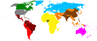
| Description |
English: Regions and eligible countries for the United States Diversity Visa lottery.
Created from Wikimedia Commons' blank world map.
|
||||||||||||||||
| Date | 29 July 2007 (original upload date) | ||||||||||||||||
| Source | Transferred from en.wikipedia to Commons. | ||||||||||||||||
| Author | Heitordp at English Wikipedia |
Regions and countries shown on the map are as defined for the allocation of visas in the United States Diversity Visa lottery. The countries are all those recognized by the United States as sovereign (all United Nations member states, Vatican City and Kosovo), in addition to Northern Ireland and Taiwan (considered separately from the United Kingdom and China for the lottery).[1]
Regions correspond to continents as they are generally understood, with some exceptions:
- North America includes only Canada and the Bahamas.[1] The United States itself is not part of the lottery. Mexico is grouped with Central and South America and the Caribbean for the lottery.[2]
- Cyprus, Turkey and all countries which used to be part of Soviet Union are allocated to Europe, even though geographically some of them are mostly or entirely in Asia.[1]
Dependent territories are treated as part of their respective sovereign countries (under those countries' regions, even if the territories are located elsewhere), and disputed territories are allocated as recognized by the United States, with some exceptions:
- Macau is treated as part of Portugal (under Europe), even after its sovereignty returned to China.[1]
- The Gaza Strip is treated as part of Egypt (under Africa), the West Bank as part of Jordan, and the Golan Heights as part of Syria (both under Asia).[1]
- Each portion of Kashmir is treated as part of the respective country administering it (India, Pakistan or China, all under Asia).[3]
- The southern Kuril Islands (Habomai, Iturup, Kunashir and Shikotan), administered by Russia and claimed by Japan, are treated as part of Japan (under Asia).[1]
- Western Sahara is a former dependent territory of Spain, currently disputed between Morocco (which administers most of the territory) and the Sahrawi Arab Democratic Republic (which administers part of it). For the lottery, as of 2019 Western Sahara is treated as part of Morocco (under Africa),[3][4] but in the past it has been treated sometimes as part of Spain (under Europe)[5] or as a separate country (under Africa).[6]
References[edit]
- ↑ a b c d e f Instructions for the 2022 Diversity Immigrant Visa Program (DV-2022) archive copy at the Wayback Machine, U.S. Department of State.
- ↑ Immigration and Nationality Act 203 - Allocation of Immigrant Visas
- ↑ a b Chargeability, 9 Foreign Affairs Manual 503.2, U.S. Department of State.
- ↑ Immigrant number use for visa issuances and adjustments of status in the diversity immigrant category, fiscal years 2010–2019, U.S. Department of State.
- ↑ Visa Bulletin For September 2013, U.S. Department of State, 12 August 2013.
- ↑ Visa Bulletin For July 2010, U.S. Department of State, 9 June 2010.
Licensing[edit]
| This work has been released into the public domain by its author, Heitordp at English Wikipedia. This applies worldwide. In some countries this may not be legally possible; if so: Heitordp grants anyone the right to use this work for any purpose, without any conditions, unless such conditions are required by law. |
Original upload log[edit]
| Date/Time | Dimensions | User | Comment |
|---|---|---|---|
| 2013-09-30 07:06 | 1480×625× (55375 bytes) | Heitordp | Updated to DV-2015 |
| 2012-10-07 11:05 | 1480×625× (55290 bytes) | Heitordp | Update to DV-2014 |
| 2011-10-04 01:43 | 1480×625× (55272 bytes) | Heitordp | More detailed map, added South Sudan, changed Mexico |
| 2011-04-21 14:42 | 1427×628× (50136 bytes) | AlexanderRa | Made Gaza yellow, Mexico dark green, Southern Sakhalin orange, Western Sahara grey |
| 2011-04-20 19:03 | 1427×628× (50354 bytes) | AlexanderRa | Reverted to version as of 12:33, 8 April 2011 - I am new to uploading and I was not able to upload the new file correctly. The colors became too dark. |
| 2011-04-20 18:53 | 1427×628× (45607 bytes) | AlexanderRa | Gaza, Western Sahara, Southern Sakhalin - they did not load somehow |
| 2011-04-20 18:47 | 1427×628× (45607 bytes) | AlexanderRa | Made Gaza yellow, made Southern Sakhalin orange, made Western Sahara grey |
| 2011-04-08 12:33 | 1427×628× (50354 bytes) | AlexanderRa | Reverted to version as of 20:41, 2 April 2011 - Reverted Canada to be North America |
| 2011-04-08 01:20 | 1427×628× (50249 bytes) | Heitordp | Fixed Gaza Strip and Southern Sakhalin, Mexico is not considered North America for the DV. |
| 2011-04-02 20:41 | 1427×628× (50354 bytes) | BGManofID | As per 2010 immigration statistics, made Poland eligible and Bangladesh ineligible; also changed Mexico to North America. |
| 2008-05-28 19:30 | 1427×628× (50384 bytes) | Heitordp | Regions and eligible countries for the [[United States]] [[Diversity Immigrant Visa| Diversity Visa lottery]]. Created from Wikimedia Commons' [[commons:Image:BlankMap-World.png|blank world map]]. *<font color=gray>'''Gray'''</font>: [[United States]] an |
| 2007-12-03 12:27 | 1427×628× (50523 bytes) | Heitordp | Regions and eligible countries for the [[United States]] [[Diversity Immigrant Visa| Diversity Visa lottery]]. Created from Wikimedia Commons' [[commons:Image:BlankMap-World.png|blank world map]]. *<font color=gray>'''Gray'''</font>: [[United States]] an |
| 2007-08-09 04:00 | 1427×628× (50500 bytes) | Heitordp | Regions and eligible countries for the [[United States]] [[Diversity Immigrant Visa| Diversity Visa lottery]]. Created from Wikimedia Commons' [[commons:Image:BlankMap-World.png|blank world map]]. *<font color=gray>'''Gray'''</font>: [[United States]] an |
| 2007-07-29 22:15 | 1427×628× (51468 bytes) | Heitordp | Regions and eligible countries for the [United States] [Diversity Visa] lottery. Created from Wikimedia Commons' [http://commons.wikimedia.org/wiki/Image:BlankMap-World.png|blank world map]. |
File history
Click on a date/time to view the file as it appeared at that time.
| Date/Time | Thumbnail | Dimensions | User | Comment | |
|---|---|---|---|---|---|
| current | 21:45, 29 September 2023 | | 1,480 × 625 (39 KB) | Heitordp (talk | contribs) | Updated to DV-2025 (UK) |
| 06:05, 3 October 2021 |  | 1,480 × 625 (39 KB) | Heitordp (talk | contribs) | Updated to DV-2023 (Guatemala and Venezuela); removed long lines | |
| 18:41, 30 September 2020 |  | 1,480 × 625 (39 KB) | Heitordp (talk | contribs) | Updated to DV-2022 (Honduras and Hong Kong); corrected position of American Samoa | |
| 05:04, 3 October 2019 |  | 1,480 × 625 (39 KB) | Heitordp (talk | contribs) | Update to DV-2021 | |
| 03:04, 11 November 2018 |  | 1,480 × 625 (39 KB) | Heitordp (talk | contribs) | Removed small islands, connected discontinuous areas with lines, added circles for small jurisdictions, marked disputed areas as allocated for the lottery, adjusted blue and yellow colors | |
| 11:06, 22 September 2016 |  | 1,480 × 625 (43 KB) | Heitordp (talk | contribs) | == {{int:filedesc}} == {{Information |Description={{en|Regions and eligible countries for the 2018 United States Diversity Visa lottery. Created from Wikimedia Commons' [[:en:commons:Image:BlankMap-World.png|blank worl... |
You cannot overwrite this file.
File usage on Commons
There are no pages that use this file.
File usage on other wikis
The following other wikis use this file:
- Usage on en.wikipedia.org