File:Dean Architects - fmr Railway Branch YMCA - Depew, New York - 20210219.jpg
Jump to navigation
Jump to search

Size of this preview: 800 × 599 pixels. Other resolutions: 320 × 240 pixels | 640 × 480 pixels | 1,024 × 767 pixels | 1,280 × 959 pixels | 1,791 × 1,342 pixels.
Original file (1,791 × 1,342 pixels, file size: 833 KB, MIME type: image/jpeg)
Captions
Captions
Add a one-line explanation of what this file represents
Summary[edit]
| Description |
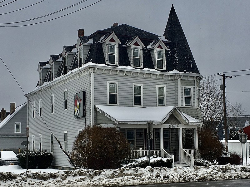
English: Dean Architects, 3284 Walden Avenue at Tyler Street, Depew, New York, February 2021. Erected in 1896 as one of the first batch of institutional buildings built by the Depew Improvement Company for the then-newly founded village, this serves as an anachronistic example of the Second Empire architectural style with its bracketed cornice, pedimented dormer windows framed by stylized columns, and of course, proud mansard roof. However, the shingle-sided, tent-roofed corner turret and the asymmetrical front porch with its off-center pediment both borrow from the Queen Anne style, which was much less passé at the time. The building functioned initially as the so-called Railroad Branch YMCA, which appears to have been defunct by 1912: a Depew Herald article from that year mentions a proposal to move the "former Y.M.C.A. building" to nearby Transit Road and convert it to a hotel, which apparently never materialized as the building remains on its original site. By 1939 it was in use as apartments, initially with a modest but respectable lower-middle-class tenant base composed mainly of workers at the machine shops and factories gathered around the New York Central Railroad line; the village's raison d'être. By the 1980s it had degenerated into a sleazy and dilapidated rooming house, and it was slated for demolition by 1998, when DeanSutton Architecture purchased the building and fully restored it for use as their offices. Dean Architects, the successor firm, remains headquartered there today. |
| Date | Taken on 19 February 2021, 10:43:48 |
| Source | Own work |
| Author | Andre Carrotflower |
| Camera location | | View this and other nearby images on: OpenStreetMap |
|---|
Licensing[edit]
I, the copyright holder of this work, hereby publish it under the following license:
This file is licensed under the Creative Commons Attribution-Share Alike 4.0 International license.
- You are free:
- to share – to copy, distribute and transmit the work
- to remix – to adapt the work
- Under the following conditions:
- attribution – You must give appropriate credit, provide a link to the license, and indicate if changes were made. You may do so in any reasonable manner, but not in any way that suggests the licensor endorses you or your use.
- share alike – If you remix, transform, or build upon the material, you must distribute your contributions under the same or compatible license as the original.
File history
Click on a date/time to view the file as it appeared at that time.
| Date/Time | Thumbnail | Dimensions | User | Comment | |
|---|---|---|---|---|---|
| current | 03:34, 25 April 2021 | | 1,791 × 1,342 (833 KB) | Andre Carrotflower (talk | contribs) | Uploaded own work with UploadWizard |
You cannot overwrite this file.
File usage on Commons
The following page uses this file:
File usage on other wikis
The following other wikis use this file:
- Usage on ar.wikipedia.org
- Usage on ca.wikipedia.org
- Usage on ceb.wikipedia.org
- Usage on cy.wikipedia.org
- Usage on es.wikipedia.org
- Usage on eu.wikipedia.org
- Usage on fr.wikipedia.org
- Usage on ht.wikipedia.org
- Usage on hu.wikipedia.org
- Usage on it.wikipedia.org
- Usage on lld.wikipedia.org
- Usage on pl.wikipedia.org
- Usage on sr.wikipedia.org
- Usage on uk.wikipedia.org
- Usage on www.wikidata.org
Metadata
Categories:
- February 2021 in New York (state)
- 2021 in Erie County, New York
- Depew, New York
- Buildings in Lancaster (town), New York
- Former YMCAs in the United States
- Office buildings in New York (state)
- Second Empire architecture in Erie County, New York
- Queen Anne architecture in Erie County, New York
- 1890s architecture in Erie County, New York
- Built in New York (state) in 1896
- Snow in Erie County, New York