File:Deccan sultanates 1490 - 1687 ad-ar.png
Jump to navigation
Jump to search

Size of this preview: 429 × 600 pixels. Other resolutions: 172 × 240 pixels | 503 × 703 pixels.
Original file (503 × 703 pixels, file size: 25 KB, MIME type: image/png)
Captions
Captions
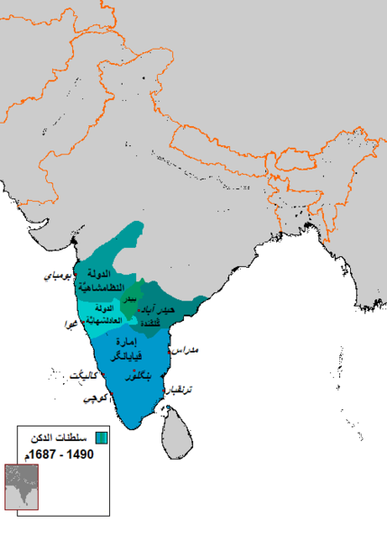
Map showing the aaproximate boarders of the Muslim Deccan sultanates and Hindu Vijayanagara Empire.
Summary
[edit]
| Description |
العربية: خريطة تُظهر الحُدُود التقريبيَّة لِلسلطنات الإسلاميَّة في الدكن بِالإضافة إلى إمارة ڤيايانگر الهندوسيَّة. |
| Date | |
| Source |
This file was derived from: Deccan sultanates 1490 - 1687 ad.png |
| Author |
|
| Other versions | English |
Licensing
[edit]
| This work has been released into the public domain by its author, Arab Hafez at English Wikipedia. This applies worldwide. In some countries this may not be legally possible; if so: Arab Hafez grants anyone the right to use this work for any purpose, without any conditions, unless such conditions are required by law. |
File history
Click on a date/time to view the file as it appeared at that time.
| Date/Time | Thumbnail | Dimensions | User | Comment | |
|---|---|---|---|---|---|
| current | 22:45, 28 June 2019 | | 503 × 703 (25 KB) | باسم (talk | contribs) | User created page with UploadWizard |
You cannot overwrite this file.
File usage on Commons
There are no pages that use this file.
File usage on other wikis
The following other wikis use this file:
- Usage on ar.wikipedia.org