File:Denmarkmap.png
Jump to navigation
Jump to search

Size of this preview: 732 × 599 pixels. Other resolutions: 293 × 240 pixels | 586 × 480 pixels | 926 × 758 pixels.
Original file (926 × 758 pixels, file size: 67 KB, MIME type: image/png)
Captions
Captions
Add a one-line explanation of what this file represents
Summary[edit]
| Description |
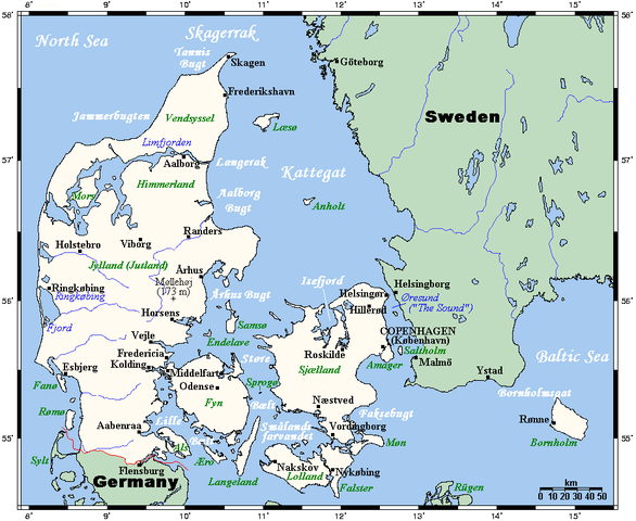
English: A map showing Denmark and nearby areas. This map's source is here, with the uploader's modifications, and the GMT homepage says that the tools are released under the GNU General Public License.
This is meant to supersede a former file called Image:Denmarkmap.gif. This version is a bit less busy but actually contains more information (well, a bit more, anyway). Kelisi 00:49, 16 July 2007 (UTC) |
| Date | |
| Source | Own work |
| Author | Kelisi |
Licensing[edit]
I, the copyright holder of this work, hereby publish it under the following license:
| This file is licensed under the Creative Commons Attribution-Share Alike 3.0 Unported license. Subject to disclaimers. | ||
| ||
| This licensing tag was added to this file as part of the GFDL licensing update. |

|
Permission is granted to copy, distribute and/or modify this document under the terms of the GNU Free Documentation License, Version 1.2 or any later version published by the Free Software Foundation; with no Invariant Sections, no Front-Cover Texts, and no Back-Cover Texts. A copy of the license is included in the section entitled GNU Free Documentation License. Subject to disclaimers. |
File history
Click on a date/time to view the file as it appeared at that time.
| Date/Time | Thumbnail | Dimensions | User | Comment | |
|---|---|---|---|---|---|
| current | 09:10, 27 May 2008 | | 926 × 758 (67 KB) | Kelisi (talk | contribs) | County boundaries removed (counties have been abolished). |
| 23:45, 28 July 2007 |  | 926 × 758 (50 KB) | Kelisi (talk | contribs) | Added Sprogø. | |
| 00:46, 16 July 2007 |  | 926 × 758 (50 KB) | Kelisi (talk | contribs) |
You cannot overwrite this file.
File usage on Commons
There are no pages that use this file.
File usage on other wikis
The following other wikis use this file:
- Usage on cs.wikipedia.org
- Usage on es.wikipedia.org
- Usage on pt.wikipedia.org
- Usage on sv.wikipedia.org