File:Diagramme du canal de Panamá.png

Original file (670 × 646 pixels, file size: 288 KB, MIME type: image/png)
Captions
Captions
Summary[edit]
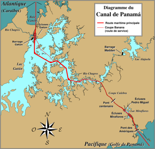
fr : Diagramme illustrant la disposition du canal de Panamá.
D'après une carte en anglais, vidée de ses noms par Ripounet.
Noms en français ajoutés par Jérôme BLUM le 9 août 2006.
À cause de la forme de l'isthme de Panamá, l'extrêmité côté Pacifique du canal est en réalité au sud-est, et l'extrémité côté Atlantique est au nord-ouest. Du côté Pacifique, les écluses Miraflores et Pedro Miguel (qui se passent respectivement en deux et une fois) amènent au plus haut point du canal : 26 mètres au-dessus du niveau de la mer. La Coupe Culebra (ou Coupe Gaillard) conduisent au lac Gatún, créé par le barrage construit sur le fleuve Chagres ; puis les écluses Gatún ramènent au niveau de la mer dans la baie Limón.
Le trait gras rouge montre la route maritime. Le trait rouge fin dans le lac Gatún est la Coupe Banane, un raccourci utilisé par des bateaux et yachts du canal.

|
Permission is granted to copy, distribute and/or modify this document under the terms of the GNU Free Documentation License, Version 1.2 or any later version published by the Free Software Foundation; with no Invariant Sections, no Front-Cover Texts, and no Back-Cover Texts. A copy of the license is included in the section entitled GNU Free Documentation License. |
| This file is licensed under the Creative Commons Attribution-Share Alike 3.0 Unported license. | ||
| ||
| This licensing tag was added to this file as part of the GFDL licensing update. |
- You are free:
- to share – to copy, distribute and transmit the work
- to remix – to adapt the work
- Under the following conditions:
- attribution – You must give appropriate credit, provide a link to the license, and indicate if changes were made. You may do so in any reasonable manner, but not in any way that suggests the licensor endorses you or your use.
- share alike – If you remix, transform, or build upon the material, you must distribute your contributions under the same or compatible license as the original.
File history
Click on a date/time to view the file as it appeared at that time.
| Date/Time | Thumbnail | Dimensions | User | Comment | |
|---|---|---|---|---|---|
| current | 06:55, 10 August 2006 | | 670 × 646 (288 KB) | Wagner51 (talk | contribs) | Noms corrigés + inversion légende des routes + changement police rose des vents |
| 06:49, 10 August 2006 |  | 670 × 646 (287 KB) | Wagner51 (talk | contribs) | Quelques noms corrigés | |
| 06:28, 10 August 2006 |  | 670 × 646 (285 KB) | Wagner51 (talk | contribs) | == Description == <div style="padding:0.5em; width:80%; border:1px solid #5555ff; background-color: #eeeeff"> '''fr :''' Diagramme illustrant la disposition du canal de Panamá.<br /> D'après une [[:en:Image:Panama Canal Rough Diagram-non annotated.png|c |
You cannot overwrite this file.
File usage on Commons
There are no pages that use this file.
File usage on other wikis
The following other wikis use this file:
- Usage on en.wikipedia.org
- Usage on fr.wikipedia.org
- Utilisateur:Wagner51
- Lac Gatún
- Wikipédia:Atelier graphique/Images à améliorer/Archives/Août 2006
- Wikipédia:Lumière sur/Septembre 2006
- Wikipédia:Lumière sur/Canal de Panama
- Wikipédia:Sélection/Eau
- Wikipédia:Sélection/Transports
- Wikipédia:Sélection/Monde maritime
- Portail:Panama/Lumière sur...
- Wikipédia:Sélection/Océan Pacifique
- Wikipédia:Sélection/Lacs et cours d'eau
- Wikipédia:Sélection/Océans
- Wikipédia:Sélection/Amérique centrale
- Phare d’entrée atlantique (milieu)
- Phare d’entrée atlantique (arrière)
- Phare de Gatún
- Wikipédia:Sélection/Technologies
- Usage on mg.wikipedia.org
- Usage on oc.wikipedia.org
- Usage on pt.wikipedia.org
- Usage on uk.wikipedia.org