File:Dickens, Charles — Besuchte Orte während der Italienreisen 1844 - 1845 + 1853 (Kartografie).jpg
Jump to navigation
Jump to search

Size of this preview: 450 × 600 pixels. Other resolutions: 180 × 240 pixels | 360 × 480 pixels | 576 × 768 pixels | 768 × 1,024 pixels | 1,536 × 2,048 pixels | 2,736 × 3,648 pixels.
Original file (2,736 × 3,648 pixels, file size: 3.19 MB, MIME type: image/jpeg)
Captions
Captions
Add a one-line explanation of what this file represents
| Camera location | | View this and other nearby images on: OpenStreetMap |
|---|
Summary
Object
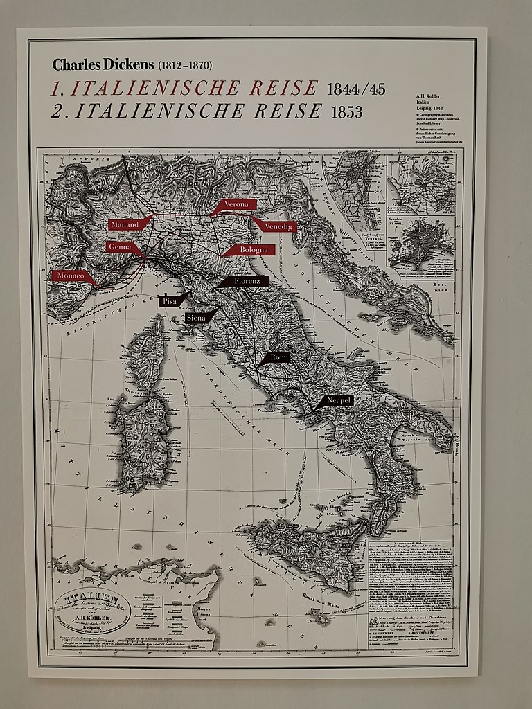
| Deutsch: Charles Dickens • Karthografierte Orte der Italienreisen von 1844 bis 1845 (rot koloriert) und 1853 (schwarz koloriert)
( |
|||||||||||||||||||||||||||
|---|---|---|---|---|---|---|---|---|---|---|---|---|---|---|---|---|---|---|---|---|---|---|---|---|---|---|---|
| Artist |
A.H. Kohler, Leipzig |
||||||||||||||||||||||||||
| Title |
Deutsch: Charles Dickens • Karthografierte Orte der Italienreisen von 1844 bis 1845 (rot koloriert) und 1853 (schwarz koloriert) |
||||||||||||||||||||||||||
| Date | map from 1848 | ||||||||||||||||||||||||||
| Collection |
|
||||||||||||||||||||||||||
| Current location |
1. OG |
||||||||||||||||||||||||||
| Place of creation |
Innsbruck |
||||||||||||||||||||||||||
| Notes | HDR | ||||||||||||||||||||||||||
| Permission (Reusing this file) |
|
||||||||||||||||||||||||||
.jpg)
.jpg¶ms=047.267357_N_0011.397620_E_globe:Earth_type:camera_alt:634.89_source:exif_&language=en)
Photograph
| Date | Taken on 15 September 2020 |
| Source | Self-photographed |
| Author | User:Mateus2019 |
| Permission (Reusing this file) |
I, the copyright holder of this work, hereby publish it under the following license: This file is licensed under the Creative Commons Attribution-Share Alike 4.0 International license.
|
File history
Click on a date/time to view the file as it appeared at that time.
| Date/Time | Thumbnail | Dimensions | User | Comment | |
|---|---|---|---|---|---|
| current | 18:10, 19 September 2020 | | 2,736 × 3,648 (3.19 MB) | Mateus2019 (talk | contribs) | == {{int:filedesc}} == {{Art Photo |artist ={{unknown}} |title ={{de|1=Charles Dickens • Karthografierte Orte der Italienreisen 1844 - 1845 + 1853} |description = |date ={{unknown}} |medium = |dimensions = |institution ={{Institution:Tiroler Landesmuseum Ferdinandeum}} in Innsbruck |references = |object history = |exhibition history = |location =1. OG |credit line = |inscrip... |
You cannot overwrite this file.
File usage on Commons
The following 5 pages use this file:
.jpg)
File usage on other wikis
The following other wikis use this file:
- Usage on de.wikipedia.org
.jpg&oldid=734167372)