File:División política y límites de la Prov. de Kazajistán Occidental.svg
Jump to navigation
Jump to search

Size of this PNG preview of this SVG file: 800 × 372 pixels. Other resolutions: 320 × 149 pixels | 640 × 298 pixels | 1,024 × 476 pixels | 1,280 × 596 pixels | 2,560 × 1,191 pixels | 2,293 × 1,067 pixels.
Original file (SVG file, nominally 2,293 × 1,067 pixels, file size: 8.7 MB)
Captions
Captions
Add a one-line explanation of what this file represents
Summary[edit]
| Description |
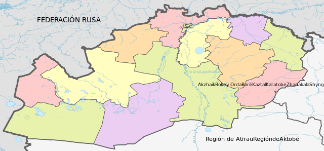
Español: Límites, distritos y la Ciudad Oral de la Reg. de Kazajistán Occidental. |
| Date | |
| Source |
Own work, using
|
| Author | Waterloo1883 |
Licensing[edit]
I, the copyright holder of this work, hereby publish it under the following license:
This file is licensed under the Creative Commons Attribution-Share Alike 4.0 International license.
- You are free:
- to share – to copy, distribute and transmit the work
- to remix – to adapt the work
- Under the following conditions:
- attribution – You must give appropriate credit, provide a link to the license, and indicate if changes were made. You may do so in any reasonable manner, but not in any way that suggests the licensor endorses you or your use.
- share alike – If you remix, transform, or build upon the material, you must distribute your contributions under the same or compatible license as the original.
File history
Click on a date/time to view the file as it appeared at that time.
| Date/Time | Thumbnail | Dimensions | User | Comment | |
|---|---|---|---|---|---|
| current | 04:06, 15 March 2024 | | 2,293 × 1,067 (8.7 MB) | Waterloo1883 (talk | contribs) | Colores más hermosos y adecuados. |
| 00:21, 24 August 2023 |  | 512 × 238 (6.32 MB) | Waterloo1883 (talk | contribs) | Reverted to version as of 14:45, 12 August 2023 (UTC) | |
| 00:20, 24 August 2023 |  | 2,293 × 1,067 (8.7 MB) | Waterloo1883 (talk | contribs) | Versión SVG más apropiado y se añadió el nombre del río Ural. | |
| 00:07, 24 August 2023 |  | 2,293 × 1,067 (8.7 MB) | Waterloo1883 (talk | contribs) | Versión SVG más apropiado y cambio de colores en la hidrografía. | |
| 14:45, 12 August 2023 |  | 512 × 238 (6.32 MB) | Waterloo1883 (talk | contribs) | Cambio en los marcos de la imagen y se añade hidrografía. | |
| 02:03, 4 October 2020 |  | 512 × 255 (610 KB) | Waterloo1883 (talk | contribs) | Uploaded own work with UploadWizard |
You cannot overwrite this file.
File usage on Commons
There are no pages that use this file.
File usage on other wikis
The following other wikis use this file:
- Usage on es.wikipedia.org