File:Driving standards historic.png
Jump to navigation
Jump to search

Size of this preview: 800 × 370 pixels. Other resolutions: 320 × 148 pixels | 640 × 296 pixels | 1,357 × 628 pixels.
Original file (1,357 × 628 pixels, file size: 36 KB, MIME type: image/png)
Captions
Captions
Add a one-line explanation of what this file represents

|
File:Driving standards historic.svg is a vector version of this file. It should be used in place of this PNG file when not inferior.
File:Driving standards historic.png → File:Driving standards historic.svg
For more information, see Help:SVG. |
 |
Summary[edit]
| Description |
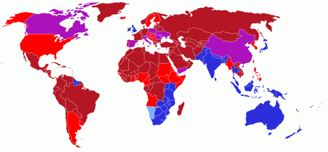
User created world map showing the driving directions for all countries and any changes that have occurred in the past starting with Finland's change in 1858
|
| Date | 13 May 2006 (original upload date) |
| Source | No machine-readable source provided. Own work assumed (based on copyright claims). |
| Author | No machine-readable author provided. UKPhoenix79 assumed (based on copyright claims). |
Licensing[edit]
I, the copyright holder of this work, hereby publish it under the following license:
This file is licensed under the Creative Commons Attribution-Share Alike 2.5 Generic license.
- You are free:
- to share – to copy, distribute and transmit the work
- to remix – to adapt the work
- Under the following conditions:
- attribution – You must give appropriate credit, provide a link to the license, and indicate if changes were made. You may do so in any reasonable manner, but not in any way that suggests the licensor endorses you or your use.
- share alike – If you remix, transform, or build upon the material, you must distribute your contributions under the same or compatible license as the original.
History on English Wikipedia[edit]
- (Delete all revisions of this file) (cur) 12:54, 16 June 2006 . . UKPhoenix79 (Talk | contribs | block) . . 1357×628 (19,631 bytes) (retry)
- (del) (rev) 04:59, 16 June 2006 . . UKPhoenix79 (Talk | contribs | block) . . 1357×628 (19,631 bytes) (Looking at a map of the Austro-Hungarian Empire it becae clear that more modern nations had parts that drove on the left)
- (del) (rev) 09:57, 26 May 2006 . . UKPhoenix79 (Talk | contribs | block) . . 1357×628 (19,565 bytes)
- (del) (rev) 08:11, 15 May 2006 . . UKPhoenix79 (Talk | contribs | block) . . 1357×628 (19,547 bytes) (Fixed error)
- (del) (rev) 07:36, 15 May 2006 . . UKPhoenix79 (Talk | contribs | block) . . 1357×628 (19,531 bytes)
- (del) (rev) 17:22, 14 May 2006 . . NFH (Talk | contribs | block) . . 1357×628 (19,312 bytes) (Reverted to earlier revision)
- (del) (rev) 17:21, 14 May 2006 . . NFH (Talk | contribs | block) . . 1357×628 (19,056 bytes) (Reverted to earlier revision)
- (del) (rev) 17:21, 14 May 2006 . . NFH (Talk | contribs | block) . . 1357×628 (19,056 bytes) (Reverted to earlier revision)
- (del) (rev) 23:42, 13 May 2006 . . UKPhoenix79 (Talk | contribs | block) . . 1357×628 (19,312 bytes)
- (del) (rev) 23:39, 13 May 2006 . . UKPhoenix79 (Talk | contribs | block) . . 1357×628 (19,271 bytes)
- (del) (rev) 14:00, 13 May 2006 . . UKPhoenix79 (Talk | contribs | block) . . 1357×628 (19,056 bytes) (User created world map showing historic driving directions for all countries before Finland's change in 1858 Red means driving on right.
Blue means driving on left.
)
File history
Click on a date/time to view the file as it appeared at that time.
| Date/Time | Thumbnail | Dimensions | User | Comment | |
|---|---|---|---|---|---|
| current | 14:50, 12 February 2018 | | 1,357 × 628 (36 KB) | Maphobbyist (talk | contribs) | South Sudan border, same color as Sudan |
| 04:25, 7 October 2008 |  | 1,357 × 628 (52 KB) | 8q67n4tqr5 (talk | contribs) | United States was one drove on left, now drives on right (1792) Category:Right- and left-hand traffic | |
| 04:23, 7 October 2008 |  | 1,357 × 628 (52 KB) | 8q67n4tqr5 (talk | contribs) | User created world map showing the driving directions for all countries and any changes that have occurred in the past starting with Finland's change in 1858 <font color="#B41624">Red - driving on right; also known as [[Left-hand_drive#Terminology|Right | |
| 14:52, 27 July 2006 |  | 1,357 × 628 (19 KB) | Conscious (talk | contribs) | newest version from en: | |
| 11:17, 26 May 2006 |  | 1,357 × 628 (19 KB) | UKPhoenix79 (talk | contribs) | Updated version | |
| 10:16, 13 May 2006 |  | 1,357 × 628 (19 KB) | UKPhoenix79 (talk | contribs) | User created world map showing historic driving directions for all countries before Finland's change in 1858 <font color="#B41624">Red means driving on right.</font><br /> <font color="#2C2EDC">Blue means driving on left.</font><br /> |
You cannot overwrite this file.
File usage on Commons
The following 3 pages use this file:
File usage on other wikis
The following other wikis use this file:
- Usage on en.wikipedia.org
- Usage on hu.wikipedia.org
- Usage on smn.wikipedia.org