File:Duchy of Wesphalia and other states, circa 1645.svg
Jump to navigation
Jump to search

Size of this PNG preview of this SVG file: 800 × 516 pixels. Other resolutions: 320 × 206 pixels | 640 × 413 pixels | 1,024 × 660 pixels | 1,280 × 826 pixels | 2,560 × 1,651 pixels.
Original file (SVG file, nominally 800 × 516 pixels, file size: 176 KB)
Captions
Captions
Add a one-line explanation of what this file represents
Summary[edit]
| Description |
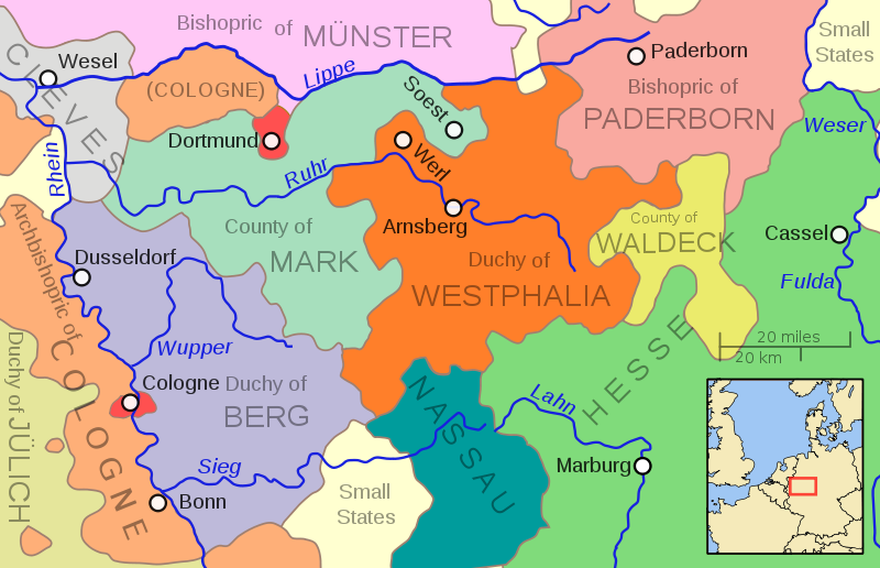
English: A map showing the Duchy of Westphalia and other eastern German states in the year 1645. Cologne and Dortmund were w:en:Free Imperial Cities. The various small Nassau and Hessian states are not shown separately. The smaller states are also not differentiated, but rather are shown in a light cream color. |
| Date | |
| Source | Own work |
| Author | MapMaster |
| Other versions | Derivative works of this file: Herzogtum Westfalen und Umland etwa 1645.svg |
References[edit]
This map was built using Roke Astrokey's excellent map File:Holy Roman Empire 1648.svg. This basic outline was modified using information from the Willem Janszoon and Joan Blaeu maps of 1645 as well as:
- "L'area' tedesca nel 1648" (1999) Atlante Storico Agostini, p. 107, ISBN 8841566841.
Licensing[edit]
I, the copyright holder of this work, hereby publish it under the following license:
This file is licensed under the Creative Commons Attribution 3.0 Unported license.
- You are free:
- to share – to copy, distribute and transmit the work
- to remix – to adapt the work
- Under the following conditions:
- attribution – You must give appropriate credit, provide a link to the license, and indicate if changes were made. You may do so in any reasonable manner, but not in any way that suggests the licensor endorses you or your use.
File history
Click on a date/time to view the file as it appeared at that time.
| Date/Time | Thumbnail | Dimensions | User | Comment | |
|---|---|---|---|---|---|
| current | 13:44, 6 May 2011 | | 800 × 516 (176 KB) | Ras67 (talk | contribs) | valid svg code |
| 03:45, 6 May 2011 |  | 800 × 516 (144 KB) | Ras67 (talk | contribs) | frame removed, 800px | |
| 04:03, 16 October 2009 |  | 704 × 459 (216 KB) | MapMaster (talk | contribs) | Needed to change page size to properly reflect enlarged drawing | |
| 21:48, 15 October 2009 |  | 352 × 229 (216 KB) | MapMaster (talk | contribs) | More river names, strict font usage, twice as large. | |
| 17:42, 15 October 2009 |  | 352 × 229 (208 KB) | MapMaster (talk | contribs) | {{Information |Description={{en|1=A map showing the Duchy of Westphalia and other eastern German states in the year 1645.}} |Source=Own work |Author=MapMaster |Date=15 October 2009 |Permission= |other_versions= }} [[Category:Maps of th |
You cannot overwrite this file.
File usage on Commons
The following page uses this file:
File usage on other wikis
The following other wikis use this file:
- Usage on bg.wikipedia.org
- Usage on cs.wikipedia.org
- Usage on es.wikipedia.org
- Usage on et.wikipedia.org
- Usage on fr.wikipedia.org
- Usage on it.wikipedia.org
- Usage on ja.wikipedia.org
- Usage on ru.wikipedia.org