File:Early French railway companies - 1937 map.svg

Original file (SVG file, nominally 709 × 868 pixels, file size: 16.45 MB)
Captions
Captions
Summary[edit]
| Description |
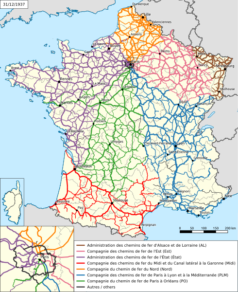
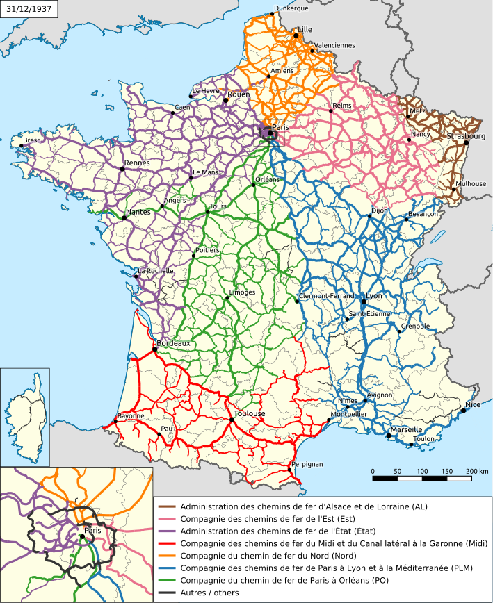
Français : Carte des réseaux d'intérêt général des compagnies de chemin de fer françaises au 31/12/1937, veille de la création de la SNCF. Chaque ligne est attribuée à son concessionnaire de jure, même si certaines concessionnaires avaient confié l'exploitation de certaines parties de leur réseau à des tiers. Seules les lignes d'intérêt général de France métropolitaine sont représentées, par opposition aux lignes d'intérêt local et aux lignes des colonies françaises.
English: Map of the general interest networks of French railway companies on December 31 1937, eve of the creation of SNCF. This map represents the concession holder de jure, although in some cases a third-person actually operated a conceded line. This map only shows general interest lines in Metropolitan France, as opposed to local interest lines and lines located in French overseas colonies. |
| Date | |
| Source | Own work |
| Author |
Français : Le dessin des frontières, des côtes et de l'hydrographie utilise des données issues des bases Geofla 2016 et EGM 2020, publiées par l'Institut géographique national sous la licence Licence ouverte / Open license d'Etalab.
English: Shapes of borders, coasts and rivers use data from Geofla 2016 and EGM 2020 databases, published by Institut géographique national under Licence ouverte / Open license from Etalab. |
Licensing[edit]

|
Permission is granted to copy, distribute and/or modify this document under the terms of the GNU Free Documentation License, Version 1.2 or any later version published by the Free Software Foundation; with no Invariant Sections, no Front-Cover Texts, and no Back-Cover Texts. A copy of the license is included in the section entitled GNU Free Documentation License. |
- You are free:
- to share – to copy, distribute and transmit the work
- to remix – to adapt the work
- Under the following conditions:
- attribution – You must give appropriate credit, provide a link to the license, and indicate if changes were made. You may do so in any reasonable manner, but not in any way that suggests the licensor endorses you or your use.
- share alike – If you remix, transform, or build upon the material, you must distribute your contributions under the same or compatible license as the original.
Although this is not compulsory, I'm always glad to read that my work is useful to others. If you could send me an e-mail at benji dot wiki at gmail dot com to inform me that you are using my work, I'd be delighted. Thanks a lot!
Envie d'utiliser cette image en dehors des projets Wikimedia ? N'hésitez pas ! Cette image est placée sous licence libre de façon à ce que vous puissiez l'utiliser librement, sans avoir besoin d'une autorisation de ma part. Tout ce que vous devez faire, c'est respecter les termes de la licence et me créditer ainsi :
Bien que ce ne soit pas obligatoire, je suis toujours ravi d'apprendre que mon travail a été utile à d'autres. Si vous pouviez m'envoyer un courriel à benji point wiki arobase gmail point com pour m'informer du fait que vous utilisez mon travail, ce serait top. Merci d'avance !
This image has been assessed using the Quality image guidelines and is considered a Quality image.
|
File history
Click on a date/time to view the file as it appeared at that time.
| Date/Time | Thumbnail | Dimensions | User | Comment | |
|---|---|---|---|---|---|
| current | 18:06, 5 November 2023 | | 709 × 868 (16.45 MB) | Benjism89 (talk | contribs) | Uploaded a work by Benjamin Smith {{fr|Le dessin des frontières, des côtes et de l'hydrographie utilise des données issues des bases Geofla 2016 et EGM 2020, publiées par l'''Institut géographique national'' sous la licence ''Licence ouverte / Open license'' d'Etalab.}} {{en|Shapes of borders, coasts and rivers use data from Geofla 2016 and EGM 2020 databases, published by ''Institut géographique national'' under ''Licence ouverte / Open license'' from Etalab.}} from {{ow... |
You cannot overwrite this file.
File usage on Commons
The following 5 pages use this file:
File usage on other wikis
The following other wikis use this file:
- Usage on fr.wikipedia.org
- Usage on ja.wikipedia.org