File:Earthquake info by Ja Cabinet office01.png
Jump to navigation
Jump to search

Size of this preview: 421 × 599 pixels. Other resolutions: 169 × 240 pixels | 337 × 480 pixels | 540 × 768 pixels | 1,121 × 1,594 pixels.
Original file (1,121 × 1,594 pixels, file size: 53 KB, MIME type: image/png)
Captions
Captions
Add a one-line explanation of what this file represents
Summary[edit]
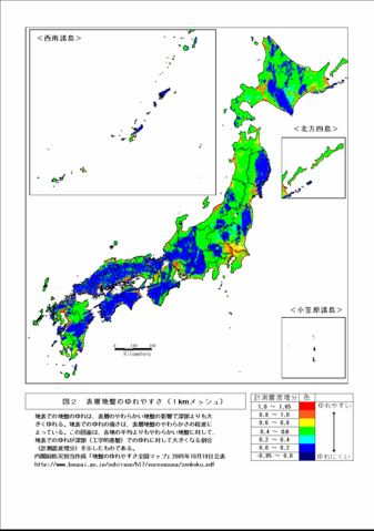
- credit:the earthquake information map released by Cabinet Office of the Japanese Government on 2005-10-19
- 出典:日本国内閣府「地盤のゆれやすさ全国マップ」2005年10月
19日公表資料 ( http://www.bousai.go.jp/oshirase/h17/yureyasusa/ archive copy at the Wayback Machine)
| Description | Quakability Map of each areas in Japan | ||
| Date | Released 2005-10-19 | ||
| Source | http://www.bousai.go.jp/oshirase/h17/yureyasusa/zenkoku.pdf | ||
| Author | Miya.m added the URL and the information to the Map made by Japanese government Cabinet officials. | ||
| Permission (Reusing this file) |
This file is licensed under the Creative Commons Attribution 4.0 International license. Attribution: 内閣府防災のページ
|

Licensing[edit]
Original work of Japanese government officials; (http://www.bousai.go.jp/oshirase/h17/yureyasusa/zenkoku.pdf archive copy at the Wayback Machine) confirmed to be CC-by-4.0
This file is licensed under the Creative Commons Attribution 4.0 International license.
- You are free:
- to share – to copy, distribute and transmit the work
- to remix – to adapt the work
- Under the following conditions:
- attribution – You must give appropriate credit, provide a link to the license, and indicate if changes were made. You may do so in any reasonable manner, but not in any way that suggests the licensor endorses you or your use.
File history
Click on a date/time to view the file as it appeared at that time.
| Date/Time | Thumbnail | Dimensions | User | Comment | |
|---|---|---|---|---|---|
| current | 01:48, 18 December 2005 | | 1,121 × 1,594 (53 KB) | Miya.m (talk | contribs) | {{Information| |Description = Quakability Map of each areas in Japan |Source = http://www.bousai.go.jp/oshirase/h17/yureyasusa/zenkoku.pdf |Date = Released 2005-10-19 |Author = Miya.m added the URL and the information to the Map made by Japanese governmen |
You cannot overwrite this file.
File usage on Commons
There are no pages that use this file.
File usage on other wikis
The following other wikis use this file:
- Usage on es.wikipedia.org
- Usage on ja.wikipedia.org
- Usage on ja.wikibooks.org