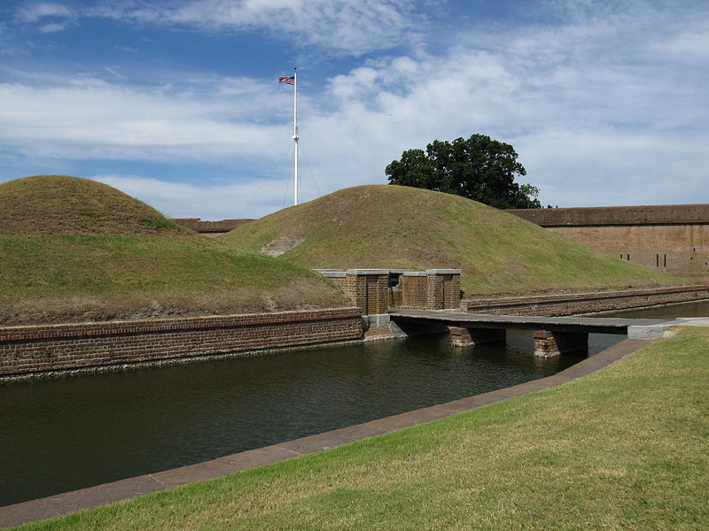
File:Entrance to the Demilune, Fort Pulaski National Monument, Cockspur Island, Georgia.jpg

Original file (4,000 × 3,000 pixels, file size: 2.98 MB, MIME type: image/jpeg)
Captions
Captions
Summary[edit]
| DescriptionEntrance to the Demilune, Fort Pulaski National Monument, Cockspur Island, Georgia.jpg |
Following the War of 1812, President James Madison ordered a new system of coastal fortifications to protect the United States against foreign invasion. Construction of a fort to protect the port of Savannah began in 1829 under the direction of Major General Babcock, and later Second Lieutenant Robert E. Lee, a recent graduate of West Point. The new fort would be located on Cockspur Island at the mouth of the Savannah River. In 1833, the new fort was named Fort Pulaski in honor of Kazimierz Pulaski, a Polish soldier and military commander who fought in the American Revolution under the command of George Washington. Pulaski was a noted cavalryman and played a large role in training Revolutionary troops. He took part in the sieges of Charleston and of Savannah. Wooden pilings were sunk up to 70 feet (21 m) into the mud to support an estimated 25,000,000 bricks. Fort Pulaski was finally completed in 1847 following 18 years of construction and nearly $1,000,001 in construction costs. Walls were eleven feet thick, thought to be impenetrable except by only the largest land artillery- which at the time were smooth bore cannon. These cannons had a range of only around a half mile, and the nearest land (Tybee island) was much further away than that. It was assumed that the Fort would be invincible to enemy attack. en.wikipedia.org/wiki/Fort_Pulaski_National_Monument en.wikipedia.org/wiki/Wikipedia:Text_of_Creative_Commons_... |
| Date | |
| Source |
Entrance to the Demilune, Fort Pulaski National Monument, Cockspur Island, Georgia
|
| Author | Ken Lund from Las Vegas, Nevada, USA |
| Camera location | 32° 01′ 40.33″ N, 80° 53′ 28.23″ W | View this and other nearby images on: OpenStreetMap |
|---|
Licensing[edit]
- You are free:
- to share – to copy, distribute and transmit the work
- to remix – to adapt the work
- Under the following conditions:
- attribution – You must give appropriate credit, provide a link to the license, and indicate if changes were made. You may do so in any reasonable manner, but not in any way that suggests the licensor endorses you or your use.
- share alike – If you remix, transform, or build upon the material, you must distribute your contributions under the same or compatible license as the original.
| This image, originally posted to Flickr, was reviewed on December 30, 2011 by the administrator or reviewer File Upload Bot (Magnus Manske), who confirmed that it was available on Flickr under the stated license on that date. |
File history
Click on a date/time to view the file as it appeared at that time.
| Date/Time | Thumbnail | Dimensions | User | Comment | |
|---|---|---|---|---|---|
| current | 19:59, 30 December 2011 |  | 4,000 × 3,000 (2.98 MB) | File Upload Bot (Magnus Manske) (talk | contribs) | {{Information |Description=Following the War of 1812, President James Madison ordered a new system of coastal fortifications to protect the United States against foreign invasion. Construction of a fort to protect the port of Savannah began in 1829 under |
You cannot overwrite this file.
File usage on Commons
There are no pages that use this file.
File usage on other wikis
The following other wikis use this file:
- Usage on en.wikipedia.org
Metadata
This file contains additional information such as Exif metadata which may have been added by the digital camera, scanner, or software program used to create or digitize it. If the file has been modified from its original state, some details such as the timestamp may not fully reflect those of the original file. The timestamp is only as accurate as the clock in the camera, and it may be completely wrong.
| Camera manufacturer | Canon |
|---|---|
| Camera model | Canon PowerShot SX130 IS |
| Exposure time | 1/1,250 sec (0.0008) |
| F-number | f/3.4 |
| ISO speed rating | 80 |
| Date and time of data generation | 13:29, 10 June 2011 |
| Lens focal length | 5 mm |
| Orientation | Normal |
| Horizontal resolution | 180 dpi |
| Vertical resolution | 180 dpi |
| File change date and time | 13:29, 10 June 2011 |
| Y and C positioning | Co-sited |
| Exif version | 2.3 |
| Date and time of digitizing | 13:29, 10 June 2011 |
| Meaning of each component |
|
| Image compression mode | 3 |
| APEX shutter speed | 10.28125 |
| APEX aperture | 3.53125 |
| APEX exposure bias | −0.66666666666667 |
| Maximum land aperture | 3.53125 APEX (f/3.4) |
| Metering mode | Pattern |
| Flash | Flash did not fire, compulsory flash suppression |
| Supported Flashpix version | 1 |
| Color space | sRGB |
| Focal plane X resolution | 16,393.442622951 |
| Focal plane Y resolution | 16,393.442622951 |
| Focal plane resolution unit | inches |
| Sensing method | One-chip color area sensor |
| File source | Digital still camera |
| Custom image processing | Normal process |
| Exposure mode | Manual exposure |
| White balance | Auto white balance |
| Digital zoom ratio | 1 |
| Scene capture type | Landscape |
| Rating (out of 5) | 0 |