File:Eocene Europe amber map.jpg
Jump to navigation
Jump to search

Size of this preview: 742 × 600 pixels. Other resolutions: 297 × 240 pixels | 594 × 480 pixels | 950 × 768 pixels | 1,267 × 1,024 pixels | 1,492 × 1,206 pixels.
Original file (1,492 × 1,206 pixels, file size: 371 KB, MIME type: image/jpeg)
Captions
Captions
Add a one-line explanation of what this file represents
Summary[edit]
| Description |
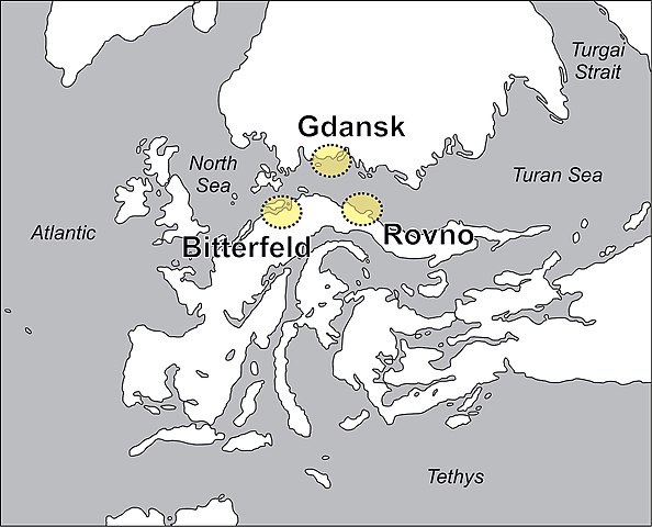
English: Paleogeographic map of Europe during the early to middle Eocene. Yellow areas indicate the position of the present-day amber Lagerstätten at Bitterfeld, Gdansk and Rovno. Modified after Popov et al. 2004, Denk and Grimm 2009, Blakey 2011, Szwedo and Sontag 2013, and Wolfe et al. 2016.
|
| Date | |
| Source | https://evolsyst.pensoft.net/article/22581/list/8/ |
| Author | Jason A. Dunlop, Ulrich Kotthoff, Jörg U. Hammel, Jennifer Ahrens, Danilo Harms |
| Permission (Reusing this file) |
This file is licensed under the Creative Commons Attribution 4.0 International license.
|
File history
Click on a date/time to view the file as it appeared at that time.
| Date/Time | Thumbnail | Dimensions | User | Comment | |
|---|---|---|---|---|---|
| current | 22:21, 5 February 2020 | | 1,492 × 1,206 (371 KB) | Hemiauchenia (talk | contribs) | Transferred from https://evolsyst.pensoft.net/showimg.php?filename=oo_193283.jpg |
You cannot overwrite this file.
File usage on Commons
There are no pages that use this file.
File usage on other wikis
The following other wikis use this file:
- Usage on en.wikipedia.org
- Usage on eo.wikipedia.org
- Usage on gl.wikipedia.org