File:Evariste Huc carte voyage.jpg
Jump to navigation
Jump to search

Size of this preview: 764 × 600 pixels. Other resolutions: 306 × 240 pixels | 612 × 480 pixels | 978 × 768 pixels | 1,280 × 1,005 pixels | 2,560 × 2,010 pixels | 3,559 × 2,794 pixels.
Original file (3,559 × 2,794 pixels, file size: 2.1 MB, MIME type: image/jpeg)
Captions
Captions
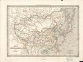
A large blurry copy of an 1850 reprint of an 1840 French map of China, Mongolia, Korea, and Japan
Summary
[edit]| Description |
English: An unfocused copy of Dufour's 1840 "Map of China and Its Tributary States", used in Huc's 1850 Remembrances of a Voyage in Tartary, Tibet, and China during the Years 1844, 1845, and 1846 with a dark line tracing the route of Huc and his fellow missionary Joseph Gabet. Note that the eastern dark line is Dufour's line tracing the Grand Canal and not Huc's route; the northeastern point beginning his route is also misplaced. Both were corrected for the 1853 2nd ed.
The Yellow River is still shown following its lower course from before the massive floods of the 1850s. Shanghai is entirely omitted as less important than Hangzhou (Hang-tcheou), Suzhou (Sou-tcheou), and Songjiang (Song-kiang, entirely misplaced to the north bank of the Yangtze). Français : Carte de la Chine et des États-Tributaires par A. H. Dufour. Carte hors-texte de la Chine par A. H. Dufour, 1840, trajet du voyage ajouté. |
| Date | |
| Source | Évariste Régis Huc's 1850 Souvenirs d'un Voyage dans la Tartarie, le Thibet et la Chine pendant les Années 1844, 1845, et 1846. Another scan of the same map is available (with zoom) at Gallica, hosted by the French National Library. |
| Author | Auguste-Henri Dufour |
| Other versions |
|


Licensing
[edit]
|
This is a faithful photographic reproduction of a two-dimensional, public domain work of art. The work of art itself is in the public domain for the following reason:
The official position taken by the Wikimedia Foundation is that "faithful reproductions of two-dimensional public domain works of art are public domain".
This photographic reproduction is therefore also considered to be in the public domain in the United States. In other jurisdictions, re-use of this content may be restricted; see Reuse of PD-Art photographs for details. | ||||
File history
Click on a date/time to view the file as it appeared at that time.
| Date/Time | Thumbnail | Dimensions | User | Comment | |
|---|---|---|---|---|---|
| current | 06:35, 17 August 2012 | | 3,559 × 2,794 (2.1 MB) | Wuyouyuan (talk | contribs) | Carte redressée, et légèrement éclaircie pour une meilleure lisibilité. Avec GIMP. |
| 05:41, 17 August 2012 |  | 3,631 × 2,859 (5.47 MB) | Wuyouyuan (talk | contribs) |
You cannot overwrite this file.
File usage on Commons
The following 6 pages use this file:
Metadata
Categories:
- French-language maps of China
- 19th-century maps of Tibet
- Qinghai Lake
- Maps of Lhasa
- Batang
- Maps by Auguste Henri Dufour
- 1850s maps of China
- 1850s maps of Taiwan
- 19th-century maps of Korea
- 19th-century maps of Mongolia
- 1850s maps of Japan
- Mongolia in the 1840s
- Tibet in the 1840s
- Maps of the Yellow River
- Engravings from France
- 1850 maps of Asia
- Maps showing 1840
- 1850 engravings
- Souvenirs d'un Voyage dans la Tartarie, le Thibet, et la Chine