File:FMIB 35438 Louisburg 1746 - Plan of Fortification at Time of the First Siege.jpeg
Jump to navigation
Jump to search

Size of this preview: 800 × 528 pixels. Other resolutions: 320 × 211 pixels | 640 × 423 pixels | 1,080 × 713 pixels.
Original file (1,080 × 713 pixels, file size: 186 KB, MIME type: image/jpeg)
Captions
Captions
Add a one-line explanation of what this file represents

|
The categories of this image need checking. You can do so here.
|
Summary[edit]
| Author |
Unknown author |
|||||||||||||||||||||||
| Description |
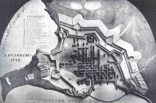
English: Louisburg 1746 : Plan of Fortification at Time of the First Siege
|
|||||||||||||||||||||||
| Date | 1903 | |||||||||||||||||||||||
| Collection |
|
|||||||||||||||||||||||
| Current location |
English: Freshwater and Marine Image Bank |
|||||||||||||||||||||||
| Accession number | ||||||||||||||||||||||||
| Source/Photographer |
English: Vernon, C. W. (1903) Cape Breton Canada at the Beginning of the Twentieth Century : a Treatise of Natural Resources and Development, Toronto, ONT: Nation Publishing Co., p. 41 |
|||||||||||||||||||||||
| Permission (Reusing this file) |
|
|||||||||||||||||||||||
File history
Click on a date/time to view the file as it appeared at that time.
| Date/Time | Thumbnail | Dimensions | User | Comment | |
|---|---|---|---|---|---|
| current | 03:01, 2 September 2015 | | 1,080 × 713 (186 KB) | BMacZeroBot (talk | contribs) |
You cannot overwrite this file.
File usage on Commons
The following page uses this file: