File:Feldberger Seen zur Havel & zur Ucker.png
Jump to navigation
Jump to search

Size of this preview: 800 × 485 pixels. Other resolutions: 320 × 194 pixels | 640 × 388 pixels | 1,024 × 620 pixels | 1,280 × 776 pixels | 2,560 × 1,551 pixels | 5,083 × 3,080 pixels.
Original file (5,083 × 3,080 pixels, file size: 5.66 MB, MIME type: image/png)
Captions
Captions
Add a one-line explanation of what this file represents
- This map in 20% projection – Cette carte en projection de 20% – Diese Karte in 20%-Projektion – 1271 x 770 px
- This map in 25% projection – Cette carte en projection de 25% – Diese Karte in 25%-Projektion – 1674 x 1027 px
- This map in 33% projection – Cette carte en projection de 33% – Diese Karte in 33%-Projektion – 2542 x 1540 px
- == Summary ==
| Description |
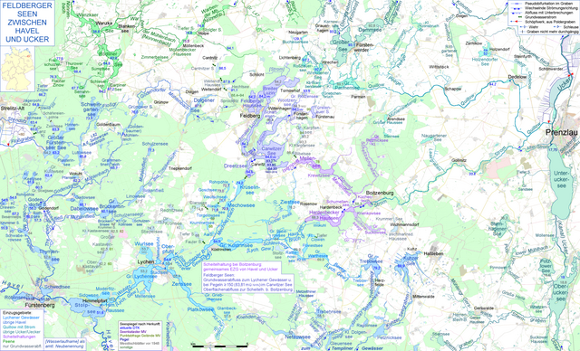
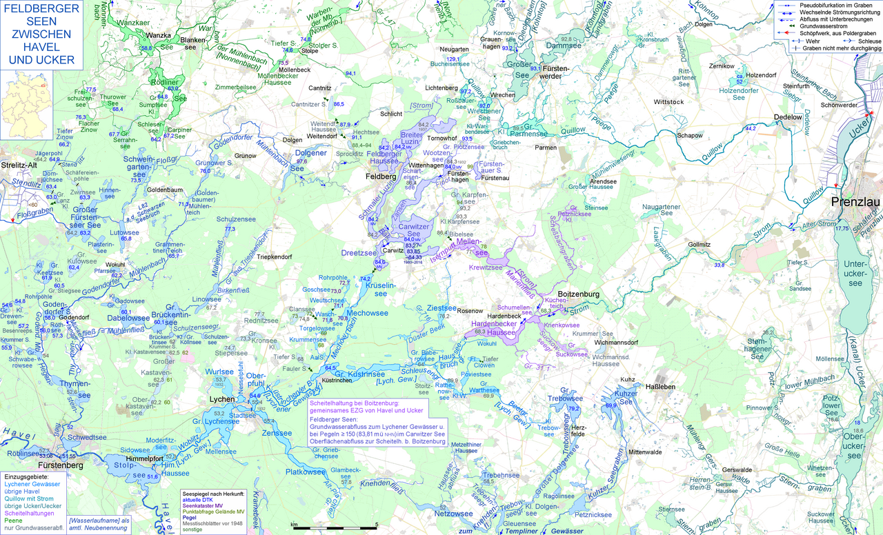
Deutsch: Die Feldberger Seen entwässern durch einen Grundwasserstrom ins Lychener Gewässer und damit zur Havel, außerdem bei ausreichendem Wasserstand im Carwitzer See durch die heute verrohrte Isernpurt zu einer Scheitelheltung bei Boitzenburg, die sowohl zu dem Einzugsgebiet der Ucker (Ablaufweg durch Strom und untere Quillow) als auch zu dem der Havel gehört (Ablaufweg wiederum durch das Lychener Gewässer). Die Karte zeigt beide Ablaufwege und reicht von der Havel bei Fürstenberg und Himmelpfort im Südwesten bis zur Ucker mit Oberuckersee, Unteruckersee und Prenzlau im Osten English: Map of the Lakes around Feldberg (the municipality of Feldberger Seenlandschaft), showing their ambiguating routes of discharge, the two western routes via ground water and via open-air waterways to river Havel at Himmelpfort near Fürstenberg and the eastern course to river Ucker near Prenzlau |
|||||||||||||||
| Date | ||||||||||||||||
| Source |
& Own work,
|
|||||||||||||||
| Author | Ulamm (talk) |
Licensing[edit]
I, the copyright holder of this work, hereby publish it under the following licenses:

|
Permission is granted to copy, distribute and/or modify this document under the terms of the GNU Free Documentation License, Version 1.2 or any later version published by the Free Software Foundation; with no Invariant Sections, no Front-Cover Texts, and no Back-Cover Texts. A copy of the license is included in the section entitled GNU Free Documentation License. |
This file is licensed under the Creative Commons Attribution-Share Alike Attribution-Share Alike 4.0 International, 3.0 Unported, 2.5 Generic, 2.0 Generic and 1.0 Generic license.
- You are free:
- to share – to copy, distribute and transmit the work
- to remix – to adapt the work
- Under the following conditions:
- attribution – You must give appropriate credit, provide a link to the license, and indicate if changes were made. You may do so in any reasonable manner, but not in any way that suggests the licensor endorses you or your use.
- share alike – If you remix, transform, or build upon the material, you must distribute your contributions under the same or compatible license as the original.
You may select the license of your choice.
File history
Click on a date/time to view the file as it appeared at that time.
| Date/Time | Thumbnail | Dimensions | User | Comment | |
|---|---|---|---|---|---|
| current | 19:02, 7 July 2019 | | 5,083 × 3,080 (5.66 MB) | Ulamm (talk | contribs) | some more details |
| 20:51, 25 June 2019 |  | 5,083 × 3,080 (5.66 MB) | Ulamm (talk | contribs) | Laakgraben is the outlet of Naugartener See. | |
| 06:40, 6 June 2019 |  | 5,083 × 3,080 (5.66 MB) | Ulamm (talk | contribs) | outlets of Kleiner Warbendesee & Großer Sandsee | |
| 07:57, 27 May 2019 |  | 5,083 × 3,080 (5.66 MB) | Ulamm (talk | contribs) | one more label | |
| 06:58, 27 May 2019 |  | 5,083 × 3,080 (5.66 MB) | Ulamm (talk | contribs) | corrections alike File:Floßgraben & Kammerkanal.png | |
| 21:58, 22 May 2019 |  | 5,083 × 3,080 (5.66 MB) | Ulamm (talk | contribs) | wells of Floßgraben | |
| 10:32, 22 May 2019 |  | 5,083 × 3,080 (5.66 MB) | Ulamm (talk | contribs) | level elevation of Carwitzer See from gauge values | |
| 17:57, 19 May 2019 |  | 5,083 × 3,080 (5.67 MB) | Ulamm (talk | contribs) | some more water level elevations | |
| 22:47, 18 May 2019 |  | 5,083 × 3,080 (5.66 MB) | Ulamm (talk | contribs) | correction of an elevation and a name, and some additions | |
| 04:34, 17 May 2019 |  | 5,083 × 3,080 (5.67 MB) | Ulamm (talk | contribs) | small details in Boitzenburg |
You cannot overwrite this file.
File usage on Commons
The following 4 pages use this file:
File usage on other wikis
The following other wikis use this file:
- Usage on de.wikipedia.org
- Usage on hu.wikipedia.org