File:Ferries in Washington (state) map.png
Jump to navigation
Jump to search

Size of this preview: 800 × 540 pixels. Other resolutions: 320 × 216 pixels | 640 × 432 pixels | 1,024 × 692 pixels | 1,280 × 865 pixels | 2,560 × 1,729 pixels | 5,487 × 3,706 pixels.
Original file (5,487 × 3,706 pixels, file size: 6.59 MB, MIME type: image/png)
Captions
Captions
Add a one-line explanation of what this file represents
Summary[edit]
_map.png&action=edit§ion=1)
| Description |
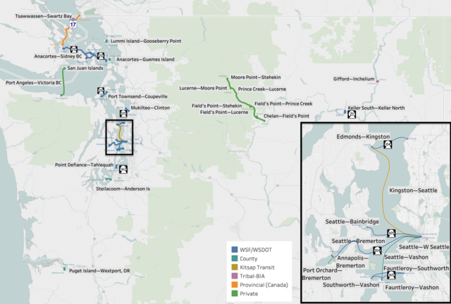
English: Map of the Ferries in Washington (state) showing routes, terminals, and ownership.
Source WSDOT GIS Data Download:
|
| Date | |
| Source | Own work |
| Author | Dennis Bratland |
Licensing[edit]
_map.png&action=edit§ion=2)
I, the copyright holder of this work, hereby publish it under the following license:
This file is licensed under the Creative Commons Attribution-Share Alike 4.0 International license.
- You are free:
- to share – to copy, distribute and transmit the work
- to remix – to adapt the work
- Under the following conditions:
- attribution – You must give appropriate credit, provide a link to the license, and indicate if changes were made. You may do so in any reasonable manner, but not in any way that suggests the licensor endorses you or your use.
- share alike – If you remix, transform, or build upon the material, you must distribute your contributions under the same or compatible license as the original.
File history
Click on a date/time to view the file as it appeared at that time.
| Date/Time | Thumbnail | Dimensions | User | Comment | |
|---|---|---|---|---|---|
| current | 00:52, 11 November 2018 | | 5,487 × 3,706 (6.59 MB) | Dennis Bratland (talk | contribs) | Add highway number shields |
| 21:08, 10 November 2018 |  | 5,487 × 3,706 (6.57 MB) | Dennis Bratland (talk | contribs) | User created page with UploadWizard |
You cannot overwrite this file.
File usage on Commons
The following 4 pages use this file:
File usage on other wikis
The following other wikis use this file:
- Usage on en.wikipedia.org
_map.png&oldid=470353424)